IMAGES TAKEN NEAR TO
Warstones Drive, WOLVERHAMPTON, WV4 4NB
Introduction
This page details the photographs taken nearby to Warstones Drive, WV4 4NB by members of the Geograph project.
The Geograph project started in 2005 with the aim of publishing, organising and preserving representative images for every square kilometre of Great Britain, Ireland and the Isle of Man.

There are currently over 7.5m images from over14,400 individuals and you can help contribute to the project by visiting https://www.geograph.org.uk
Image Map
Images are licensed for reuse under creativecommons.org/licenses/by-sa/2.0
Notes
- Clicking on the map will re-center to the selected point.
- The higher the marker number, the further away the image location is from the centre of the postcode.
Image Listing (18 Images Found)
Images are licensed for reuse under creativecommons.org/licenses/by-sa/2.0
Image
Details
Distance
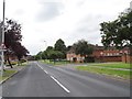
1
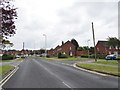
Stourton Drive View
The view from Warstones Drive in Lower Penn, Wolverhampton.
Image: © Gordon Griffiths
Taken: 13 Jul 2019
0.07 miles
2
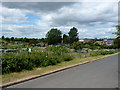
Boundary Road allotments
Council-run allotments on Boundary Road, Warstones. The Highfields Secondary School, now calling itself a Science Specialist School, is in the background.
Image: © Richard Law
Taken: 5 Jul 2010
0.11 miles
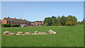
3
Swancote Drive in Warstones, Wolverhampton
Looking west towards Highfields School, from Warstones Green.
Image: © Roger Kidd
Taken: 17 Sep 2020
0.13 miles
4
Play area on Warstones Drive
A small play area for children, on the junction of Warstones Drive and Hamble Road.
Image: © Richard Law
Taken: 5 Jul 2010
0.15 miles
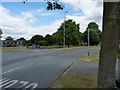
5
Warstones Drive
The view along Warstones Drive in Lower Penn, Wolverhampton.
Image: © Gordon Griffiths
Taken: 13 Jul 2019
0.16 miles
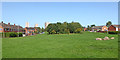
6
Warstones Green near Penn in Wolverhampton
Looking north-west towards housing in North Green. I wonder if the younger children call their only play equipment "the war stones" and have mock battles!
Image: © Roger Kidd
Taken: 17 Sep 2020
0.17 miles
7
Warstones Green near Penn in Wolverhampton
Looking north towards Merry Hill from near Swancote Drive.
Image: © Roger Kidd
Taken: 17 Sep 2020
0.20 miles
8
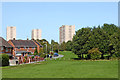
Warstones Green near Penn in Wolverhampton
Looking north towards the three tower blocks in Merry Hill. From left to right are Highfields Court, St Joseph's Court and Pennwood Court. Houses on the left are in North Green.
Image: © Roger Kidd
Taken: 17 Sep 2020
0.20 miles
9
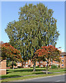
Trees and housing by Warstones Drive in Wolverhampton
Looking north-east towards housing in Warstones Gardens.
Image: © Roger Kidd
Taken: 17 Sep 2020
0.20 miles
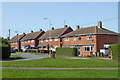
10
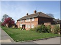
Council Housing - Warstones Drive
Stylistically these appear to be 1950s though are not shown on my late 1960s streetmap.
Image: © John M
Taken: 9 Apr 2011
0.21 miles