IMAGES TAKEN NEAR TO
Pinfold Lane, WOLVERHAMPTON, WV4 4EE
Introduction
This page details the photographs taken nearby to Pinfold Lane, WV4 4EE by members of the Geograph project.
The Geograph project started in 2005 with the aim of publishing, organising and preserving representative images for every square kilometre of Great Britain, Ireland and the Isle of Man.

There are currently over 7.5m images from over14,400 individuals and you can help contribute to the project by visiting https://www.geograph.org.uk
Image Map
Images are licensed for reuse under creativecommons.org/licenses/by-sa/2.0
Notes
- Clicking on the map will re-center to the selected point.
- The higher the marker number, the further away the image location is from the centre of the postcode.
Image Listing (133 Images Found)
Images are licensed for reuse under creativecommons.org/licenses/by-sa/2.0
Image
Details
Distance
1
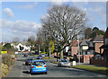
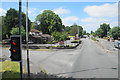
Pinfold Lane in Penn, Wolverhampton
This road leads from the main Wolverhampton-Kidderminster road (A449) here http://www.geograph.org.uk/photo/1751751 , northwards towards Warstones. Shame about the lamp posts; they don't even pretend to be vertical!
Image: © Roger D Kidd
Taken: 9 Mar 2010
0.04 miles
2
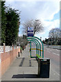
Bus stop on Penn Road A449, Wolverhampton
At the junction with Church Hill, the 254, 255 and 256 buses from Merry Hill, Stourbridge, and Wombourne stop here every few minutes en route for the city bus station.
Image: © Roger D Kidd
Taken: 9 Mar 2010
0.06 miles
3
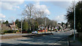
Pinfold Lane View
The view of the junction on the Penn Road in Penn, Wolverhampton.
Image: © Gordon Griffiths
Taken: 11 Feb 2021
0.06 miles
5
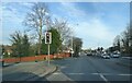
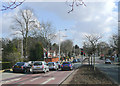
Penn Road A449, Wolverhampton
This is at the junction with Pinfold Lane, which goes northwards (left) to Warstones. A short distance ahead the Penn Road becomes single carriageway, and traffic hold-ups occur every weekday morning (07:45-09:15), and evening after 15:30.
Image: © Roger D Kidd
Taken: 9 Mar 2010
0.07 miles
6
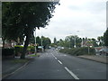
Penn Road A449, Wolverhampton
This is at the junction with Pinfold Lane, which goes to the left (north) towards Warstones. Wolverhampton city centre is about two miles ahead. The A449 then continues north to Stafford
Image: © Roger D Kidd
Taken: 9 Mar 2010
0.07 miles
7
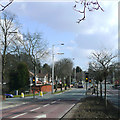
Penn Road A449, Wolverhampton
This is at the junction with Pinfold Lane, which goes northwards (left) to Warstones. A short distance ahead the Penn Road becomes single carriageway, and traffic hold-ups occur every weekday morning, and evening. The bus is picking up passengers at the Church Hill stop. Image
Image: © Roger D Kidd
Taken: 9 Mar 2010
0.07 miles
8
Road junction on Penn Road
The junction with Church Hill, with the Rose & Crown chain pub on the corner.
Image: © Bill Boaden
Taken: 22 Jun 2018
0.08 miles
9
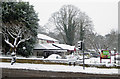
The Rose and Crown in Penn, Wolverhampton
The Rose and Crown replaced an earlier public house of the same name in the late 1970s(?) and is by the A449 Penn Road about two miles south-west of Wolverhampton city centre.
It is seen here from Church Hill on a very wintery afternoon.
Image: © Roger D Kidd
Taken: 10 Dec 2017
0.09 miles
10
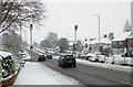
The A449 Penn Road in Wolverhampton
This is the A449 Penn Road, looking west towards Wombourne, Kingswinford and Kidderminster. Turn left at the traffic lights to ascend Church Hill towards Penn Common.
Image: © Roger D Kidd
Taken: 10 Dec 2017
0.09 miles