IMAGES TAKEN NEAR TO
Wells Road, WOLVERHAMPTON, WV4 4BH
Introduction
This page details the photographs taken nearby to Wells Road, WV4 4BH by members of the Geograph project.
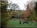
The Geograph project started in 2005 with the aim of publishing, organising and preserving representative images for every square kilometre of Great Britain, Ireland and the Isle of Man.

There are currently over 7.5m images from over14,400 individuals and you can help contribute to the project by visiting https://www.geograph.org.uk
Image Map
Images are licensed for reuse under creativecommons.org/licenses/by-sa/2.0
Notes
- Clicking on the map will re-center to the selected point.
- The higher the marker number, the further away the image location is from the centre of the postcode.
Image Listing (143 Images Found)
Images are licensed for reuse under creativecommons.org/licenses/by-sa/2.0
Image
Details
Distance
1
Wells Road
The view in Penn, Wolverhampton.
Image: © Gordon Griffiths
Taken: 13 Jul 2019
0.03 miles
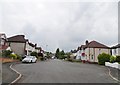
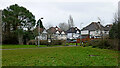
2
Wells Road in Penn, Wolverhampton
Looking south-east, Linton Road transforms into Wells Road. There is a footpath off to the left leading to Windsor Avenue. The playing fields are behind the camera.
Image: © Roger Kidd
Taken: 25 Dec 2022
0.07 miles
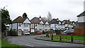
3
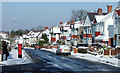
Semi-detached housing, Penn, Wolverhampton
Popular housing in Pennhouse Avenue built in the 1920s/1930s.
Image: © Roger D Kidd
Taken: 3 Feb 2009
0.07 miles
4
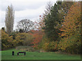
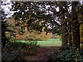
Woodlands Walk in Penn, Wolverhampton
This is a surprisingly secluded three hundred metre strip of open grass and woodland just off the busy A449 dual carriageway of Penn Road and enclosed between Lancaster Gardens and Wells Road. To find it, follow the footpath alongside the Roebuck public house.
Image: © Roger D Kidd
Taken: 2 Nov 2011
0.07 miles
5
Woodlands Walk in Penn, Wolverhampton
This is a surprisingly secluded three hundred metre strip of open grass and woodland just off the busy A449 dual carriageway of Penn Road and enclosed between Lancaster Gardens and Wells Road. To find it, follow the footpath alongside the Roebuck public house.
Image: © Roger D Kidd
Taken: 2 Nov 2011
0.07 miles
6
Woodlands Walk, Penn, Wolverhampton
This pleasant and secluded small linear park between the housing includes mature trees, an open area, and a public footpath linking the A449 (Penn Road) with Linton Road.
Image: © Roger D Kidd
Taken: 3 Feb 2009
0.08 miles
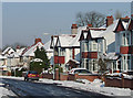
7
Pennhouse Avenue, Penn, Wolverhampton
This popular area has many 1920s/1930s semi-detached houses. The George VI post box is by the junction with Wells Road.
Image: © Roger D Kidd
Taken: 3 Feb 2009
0.08 miles
8
Woodlands Walk in Penn, Wolverhampton
This is a surprisingly secluded three hundred metre strip of open grass and woodland just off the busy A449 dual carriageway of Penn Road and enclosed between Lancaster Gardens and Wells Road. To find it, follow the footpath alongside the Roebuck public house.
Image: © Roger D Kidd
Taken: 2 Nov 2011
0.08 miles
9

Woodlands Walk, Penn, Wolverhampton
This pleasant and secluded small linear park between the housing includes mature trees, an open area, and a public footpath linking the A449 (Penn Road) with Linton Road.
Image: © Roger D Kidd
Taken: 3 Feb 2009
0.09 miles
10
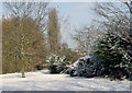
Spots field and housing in Penn, Wolverhampton
Looking east towards Wells Road from the Windsor Avenue Playing Fields.
Image: © Roger Kidd
Taken: 25 Dec 2022
0.09 miles