IMAGES TAKEN NEAR TO
Osborne Road, WOLVERHAMPTON, WV4 4BA
Introduction
This page details the photographs taken nearby to Osborne Road, WV4 4BA by members of the Geograph project.
The Geograph project started in 2005 with the aim of publishing, organising and preserving representative images for every square kilometre of Great Britain, Ireland and the Isle of Man.

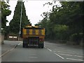
There are currently over 7.5m images from over14,400 individuals and you can help contribute to the project by visiting https://www.geograph.org.uk
Image Map
Images are licensed for reuse under creativecommons.org/licenses/by-sa/2.0
Notes
- Clicking on the map will re-center to the selected point.
- The higher the marker number, the further away the image location is from the centre of the postcode.
Image Listing (146 Images Found)
Images are licensed for reuse under creativecommons.org/licenses/by-sa/2.0
Image
Details
Distance
1
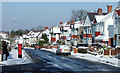
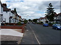
Pennhouse Avenue, Penn, Wolverhampton
This popular area has many 1920s/1930s semi-detached houses. The George VI post box is by the junction with Wells Road.
Image: © Roger D Kidd
Taken: 3 Feb 2009
0.07 miles
2
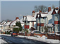
Semi-detached housing, Penn, Wolverhampton
Popular housing in Pennhouse Avenue built in the 1920s/1930s.
Image: © Roger D Kidd
Taken: 3 Feb 2009
0.08 miles
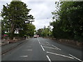
3
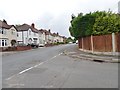
Pennhouse Avenue
The view of the junction with Wells Road in Penn, Wolverhampton.
Image: © Gordon Griffiths
Taken: 13 Jul 2019
0.10 miles
4
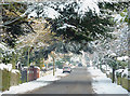
Wells Road
The view in Penn, Wolverhampton.
Image: © Gordon Griffiths
Taken: 13 Jul 2019
0.11 miles
5
Penn Road (A449) at Osborne Road junction
This section of the A449 is unimproved urban single carriageway. It's even legal to park at the roadside, effectively blocking half the road completely. A tedious bottleneck.
Image: © J Whatley
Taken: 6 Sep 2010
0.12 miles
6
Penn Road
The view of the A449 road in Penn, Wolverhampton.
Image: © Gordon Griffiths
Taken: 25 Aug 2020
0.13 miles
7
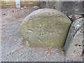
Old Boundary Marker by the A449, Penn Road, Wolverhampton Parish
Boundary Marker by the A449, in parish of Wolverhampton (Wolverhampton District), South of Osborne Road junction, North side of road, Penn, in pavement in front of wall.
Recorded as a milestone on Old-maps.
Surveyed
Milestone Society National ID: ST_WVKD02bm
Image: © Milestone Society
Taken: Unknown
0.13 miles
8
Wells Road in Penn, Wolverhampton
Looking south-east, Linton Road transforms into Wells Road. There is a footpath off to the left leading to Windsor Avenue. The playing fields are behind the camera.
Image: © Roger Kidd
Taken: 25 Dec 2022
0.15 miles
9
Wynn Road, Penn Fields
Semi detached houses on Wynn Road, Penn Fields.
Image: © Richard Law
Taken: 5 Jul 2010
0.15 miles
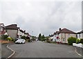
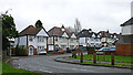
10
Muchall Road in Penn, Wolverhampton
Substantial detached houses were built here in the 1930s. Several, with nothing wrong with them, have been demolished in the 1980s/1990s to make way for the profitability of unattractive apartment blocks and a council care home which has already been closed due to changes in social "policy".
Image: © Roger D Kidd
Taken: 22 Dec 2010
0.16 miles