IMAGES TAKEN NEAR TO
Clark Road, WOLVERHAMPTON, WV3 9NW
Introduction
This page details the photographs taken nearby to Clark Road, WV3 9NW by members of the Geograph project.
The Geograph project started in 2005 with the aim of publishing, organising and preserving representative images for every square kilometre of Great Britain, Ireland and the Isle of Man.

There are currently over 7.5m images from over14,400 individuals and you can help contribute to the project by visiting https://www.geograph.org.uk
Image Map
Images are licensed for reuse under creativecommons.org/licenses/by-sa/2.0
Notes
- Clicking on the map will re-center to the selected point.
- The higher the marker number, the further away the image location is from the centre of the postcode.
Image Listing (91 Images Found)
Images are licensed for reuse under creativecommons.org/licenses/by-sa/2.0
Image
Details
Distance
1
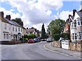
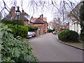
Clark Road
The view in Merridale Wolverhampton.
Image: © Gordon Griffiths
Taken: 5 Aug 2017
0.02 miles
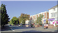
2
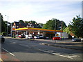
Shell petrol station, Tettenhall Road, Wolverhampton
Image: © Richard Law
Taken: 12 Jun 2009
0.04 miles
3
Park Dale East
The view from the Tettenhall Road in Wolverhampton.
Image: © Gordon Griffiths
Taken: 20 Mar 2016
0.04 miles
4
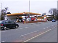
Shell Garage
The view of the Shell petrol station on the Tettenhall Road(A41) in Wolverhampton.
Image: © Gordon Griffiths
Taken: 20 Mar 2016
0.04 miles
5
The Beeches
The view of the Close from the Tettenhall Road in Wolverhampton.
Image: © Gordon Griffiths
Taken: 20 Mar 2016
0.05 miles
6
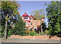
House on the Tettenhall Road, Wolverhampton
This grand establishment is a very substantial semi-detached late Victorian villa at the corner of Park Dale West, fronting onto Tettenhall Road, which is the A41 to Newport, Whitchurch and Chester. There are fifteen such unspoiled and well maintained buildings in Park Dale West under consideration for "listing".
As Wolverhampton spread along this road in the late 19th and early 20th centuries, most of the dwellings were built for the more affluent members of society. Many of the grander premises are now divided into flats, or used for small businesses or offices.
Image: © Roger D Kidd
Taken: 13 Oct 2010
0.06 miles
7
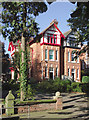
Substantial housing in Tettenhall, Wolverhampton
Park Drive West contains very substantial late Victorian semi-detached villas, the red one fronting onto Tettenhall Road, the A41 road to Newport, Whitchurch and Chester. These unspoiled and superbly maintained villas are being considered for "listing".
As Wolverhampton spread along this road in the late 19th and early 20th centuries, most of the dwellings were built for the more affluent members of society. Many of the grander premises are now divided into flats, or used for small professional businesses or offices.
See the view from Tettenhall Road: Image
Image: © Roger D Kidd
Taken: 13 Oct 2010
0.06 miles
8
Rupert Street
The view in Merridale, Wolverhampton.
Image: © Gordon Griffiths
Taken: 5 Aug 2017
0.06 miles
9
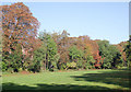
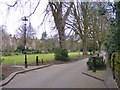
The Parkdale Conservation Area, Wolverhampton
This is an attractive well maintained (privately) strip of open land between Park Drive West (and its very up-market housing) and Park Drive east. Dog walking by non-residents is prohibited! It is not a public area, though access is not prevented. The excellent care is provided by the Parkdale Residents' Association.
Image: © Roger D Kidd
Taken: 13 Oct 2010
0.06 miles
10
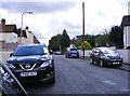
Tettenhall Road, Wolverhampton
This is the A41 about a mile outside the city centre, approaching Newbridge. The road leads to Newport, Whitchurch and Chester. The large terraced building on the right is part 19th century (listed), and part replica from the late twentieth century. Image
Image: © Roger D Kidd
Taken: 13 Oct 2010
0.07 miles