IMAGES TAKEN NEAR TO
Finchfield Road, WOLVERHAMPTON, WV3 9LQ
Introduction
This page details the photographs taken nearby to Finchfield Road, WV3 9LQ by members of the Geograph project.
The Geograph project started in 2005 with the aim of publishing, organising and preserving representative images for every square kilometre of Great Britain, Ireland and the Isle of Man.

There are currently over 7.5m images from over14,400 individuals and you can help contribute to the project by visiting https://www.geograph.org.uk
Image Map
Images are licensed for reuse under creativecommons.org/licenses/by-sa/2.0
Notes
- Clicking on the map will re-center to the selected point.
- The higher the marker number, the further away the image location is from the centre of the postcode.
Image Listing (104 Images Found)
Images are licensed for reuse under creativecommons.org/licenses/by-sa/2.0
Image
Details
Distance
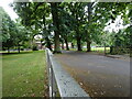
1
Park Entrance
The view of the entrance into Bantock Park from Finchfield Road in Wolverhampton.
Image: © Gordon Griffiths
Taken: 10 Dec 2016
0.02 miles
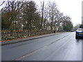
2
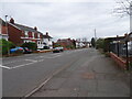
Finchfield Road Houses
The view in Merridale, Wolverhampton.
Image: © Gordon Griffiths
Taken: 4 Jun 2017
0.03 miles
3
Bantock Drive
The view of the drive to Bantock House Park off Finchfield Road, Wolverhampton.
Image: © Gordon Griffiths
Taken: 3 Jul 2022
0.05 miles
4
Snowdrops Scene
The view in the Edwardian House Museum gardens at Bantock Park.
Image: © Gordon Griffiths
Taken: 27 Jan 2020
0.05 miles
5
Victorian housing by Bantock Park, Wolverhampton
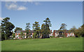
Bantock Park occupies the triangle formed by Broad Lane, Finchfield Road and Bradmore Road. Bantock House and Museum are towards the eastern corner of the park.
This view from the eastern half of the pitch and putt course looks towards a row of fourteen late Victorian semi-detached houses in Finchfield Road.
Football pitches and a children's play area are also available.
The city council's website informs us that the park is approximately 16 hectares (39.53 acres) in area. The west of the park is mostly open space, which still retains its 'rural' character, with gently undulating ground, hedgerows and a variety of trees with a nature trail. The eastern side of the park changes near Bantock House, becoming more formal. This area consists of a series of recently restored gardens, reminiscent of the detail emerging around the late nineteenth/twentieth century.
The park was originally a farm owned by the Bantock family. The house and land, comprising 16 hectares, were bequeathed to the corporation of Wolverhampton (for use as a public park) on the death of the Alderman Albert Baldwin Bantock in 1938.
Image: © Roger D Kidd
Taken: 20 Oct 2010
0.05 miles
6
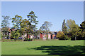
In Bantock Park at Bradmore, Wolverhampton
Bantock Park occupies the triangle formed by Broad Lane, Finchfield Road and Bradmore Road. Bantock House and Museum are towards the eastern corner of the park.
This view from the eastern half of the pitch and putt course looks towards a row of fourteen late Victorian semi-detached houses in Finchfield Road.
Football pitches and a children's play area are also available.
The city council's website informs us that the park is approximately 16 hectares (39.53 acres) in area. The west of the park is mostly open space, which still retains its 'rural' character, with gently undulating ground, hedgerows and a variety of trees with a nature trail. The eastern side of the park changes near Bantock House, becoming more formal. This area consists of a series of recently restored gardens, reminiscent of the detail emerging around the late nineteenth/twentieth century.
Image: © Roger D Kidd
Taken: 20 Oct 2010
0.05 miles
8
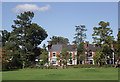
Victorian housing by Bantock Park, Wolverhampton
Bantock Park occupies the triangle formed by Broad Lane, Finchfield Road and Bradmore Road. Bantock House and Museum are towards the eastern corner of the park.
This view from the eastern half of the pitch and putt course looks towards the end four from a row of fourteen late Victorian semi-detached houses in Finchfield Road.
The park was originally a farm owned by the Bantock family. The house and land, comprising 16 hectares, were bequeathed to the corporation of Wolverhampton (for use as a public park) on the death of the Alderman Albert Baldwin Bantock in 1938.
Image: © Roger D Kidd
Taken: 20 Oct 2010
0.06 miles
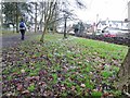
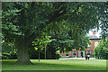
9
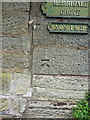
OS benchmark - Merridale, 43 Finchfield Road
A rather 'non-standard' benchmark cut into the wall near to 43 Finchfield Road; if this is indeed the original OS mark, then it was levelled at 129.266m above Ordnance Datum Newlyn.
Image: © Richard Law
Taken: 3 Aug 2015
0.07 miles
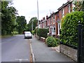
10
Richmond Road View
The view in Merridale, Wolverhampton.
Image: © Gordon Griffiths
Taken: 5 Mar 2023
0.07 miles