IMAGES TAKEN NEAR TO
Minsterley Close, WOLVERHAMPTON, WV3 7JB
Introduction
This page details the photographs taken nearby to Minsterley Close, WV3 7JB by members of the Geograph project.
The Geograph project started in 2005 with the aim of publishing, organising and preserving representative images for every square kilometre of Great Britain, Ireland and the Isle of Man.

There are currently over 7.5m images from over14,400 individuals and you can help contribute to the project by visiting https://www.geograph.org.uk
Image Map
Images are licensed for reuse under creativecommons.org/licenses/by-sa/2.0
Notes
- Clicking on the map will re-center to the selected point.
- The higher the marker number, the further away the image location is from the centre of the postcode.
Image Listing (93 Images Found)
Images are licensed for reuse under creativecommons.org/licenses/by-sa/2.0
Image
Details
Distance
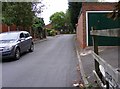
1
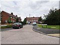
Minsterley Close
The view from Wenlock Avenue in Bradmore, Wolverhampton.
Image: © Gordon Griffiths
Taken: 14 Jul 2019
0.02 miles
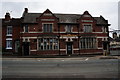
2
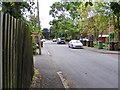
Star Street Scene
The view in Bradmore, Wolverhampton.
Image: © Gordon Griffiths
Taken: 4 Jun 2017
0.04 miles
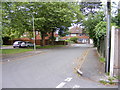
3
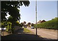
Wenlock Avenue
The view down the street in Bradmore, Wolverhampton.
Image: © Gordon Griffiths
Taken: 5 Jun 2016
0.05 miles
4
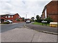
Wenlock Avenue View
The view up Wrekin Drive from Wenlock Avenue in Bradmore, Wolverhampton.
Image: © Gordon Griffiths
Taken: 14 Jul 2019
0.06 miles
5
Star Street
The view from Broad Lane in Bradmore, Wolverhampton.
Image: © Gordon Griffiths
Taken: 4 Jun 2017
0.06 miles
6
Wool Shop View
The view over Trysull Road in Bradmore, Wolverhampton.
Image: © Gordon Griffiths
Taken: 5 Jun 2016
0.07 miles
7
Star Street View
The view near Broad Lane in Bradmore, Wolverhampton.
Image: © Gordon Griffiths
Taken: 4 Jun 2017
0.07 miles
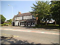
10
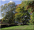
Bantock Park at Bradmore, Wolverhampton
By Broad Lane, looking north-west.
The park was originally a farm owned by the Bantock family. The house and land, comprising 16 hectares, were bequeathed to the corporation of Wolverhampton (for use as a public park) on the death of the Alderman Albert Baldwin Bantock in 1938.
Image: © Roger D Kidd
Taken: 20 Oct 2010
0.08 miles