IMAGES TAKEN NEAR TO
Eagle Street, WOLVERHAMPTON, WV3 7DN
Introduction
This page details the photographs taken nearby to Eagle Street, WV3 7DN by members of the Geograph project.
The Geograph project started in 2005 with the aim of publishing, organising and preserving representative images for every square kilometre of Great Britain, Ireland and the Isle of Man.

There are currently over 7.5m images from over14,400 individuals and you can help contribute to the project by visiting https://www.geograph.org.uk
Image Map
Images are licensed for reuse under creativecommons.org/licenses/by-sa/2.0
Notes
- Clicking on the map will re-center to the selected point.
- The higher the marker number, the further away the image location is from the centre of the postcode.
Image Listing (142 Images Found)
Images are licensed for reuse under creativecommons.org/licenses/by-sa/2.0
Image
Details
Distance
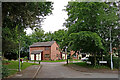
1
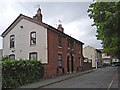
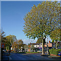
Poplar Road in Penn Fields, Wolverhampton
Looking north-east towards Eagle Street.
Image: © Roger Kidd
Taken: 26 May 2022
0.02 miles
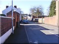
2
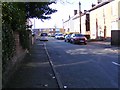
Duke Street
The view down the Wolverhampton street.
Image: © Gordon Griffiths
Taken: 25 Feb 2018
0.02 miles
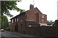
3
Chequer Street in Penn Fields, Wolverhampton
Looking south-west towards Eagle Street.
Image: © Roger Kidd
Taken: 26 May 2022
0.04 miles
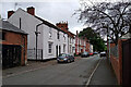
4
Houses in Poplar Road, Penn Fields in Wolverhampton
Looking south-west towards Riley Crescent.
Image: © Roger Kidd
Taken: 26 May 2022
0.04 miles
5
Worcester Close, off Eagle Street in Penn Fields, Wolverhampton
Looking south-west from the corner of Eagle Street and Chequer Street (behind the camera).
Image: © Roger Kidd
Taken: 26 May 2022
0.04 miles
6
Chequer Street View
The view down the Wolverhampton street.
Image: © Gordon Griffiths
Taken: 25 Feb 2018
0.05 miles
7
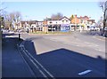
Stubbs Road Island
The view in Wolverhampton.
Image: © Gordon Griffiths
Taken: 25 Feb 2018
0.05 miles
8
Poplar Road
The view on a very rainy day in Penn Fields, Wolverhampton.
Image: © Gordon Griffiths
Taken: 28 Aug 2020
0.05 miles
9
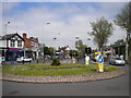
The island, Penn Fields
When I was at junior school, this roundabout was always referred to simply as "the island", which was sufficient as such things are rare in Penn Fields. It is at the south end of Lea Road (centre), where that thoroughfare meets the B4161 (Stubbs Road to the east, Birches Barn Road to the west). Wolverhampton Corporation trolleybus (motorbus from 1963) route 4, from the town centre via Lea Road, turned in this junction. The present bus route serving this area continues from here to Warstones estate; buses have not terminated here for many years. The shops here exist only on one side of the junction, the parade beginning on Birches Barn Road (out of frame to the left) and continuing a little way along Jeffcock Road (off Lea Road behind the bus shelter).
Image: © Richard Vince
Taken: 6 Jun 2013
0.06 miles
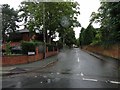
10
Stubbs Road junction near Penn Fields, Wolverhampton
Looking north-west towards the roundabout junction with Lea Road (right) and Birches Barn Road (ahead). This is the B4161 to Compton.
Image: © Roger Kidd
Taken: 31 Oct 2021
0.06 miles