IMAGES TAKEN NEAR TO
Lea Road, WOLVERHAMPTON, WV3 0LJ
Introduction
This page details the photographs taken nearby to Lea Road, WV3 0LJ by members of the Geograph project.
The Geograph project started in 2005 with the aim of publishing, organising and preserving representative images for every square kilometre of Great Britain, Ireland and the Isle of Man.

There are currently over 7.5m images from over14,400 individuals and you can help contribute to the project by visiting https://www.geograph.org.uk
Image Map
Images are licensed for reuse under creativecommons.org/licenses/by-sa/2.0
Notes
- Clicking on the map will re-center to the selected point.
- The higher the marker number, the further away the image location is from the centre of the postcode.
Image Listing (148 Images Found)
Images are licensed for reuse under creativecommons.org/licenses/by-sa/2.0
Image
Details
Distance
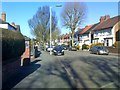
1
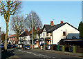
Lea Road, Penn Fields, Wolverhampton
Substantial semi-detached houses and villas were built in Lea Road in the early part of the 20th century. Several corner shops and other small businesses are still operating in this thriving multi-cultural part of Wolverhampton.
Image: © Roger D Kidd
Taken: 26 Dec 2008
0.02 miles
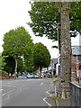
2
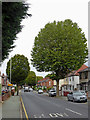
Lea Road, Penn Fields, Wolverhampton
This is at the junction with Lyndhurst Road. Much of the housing in Lea Road and locally to the north-west was built early in the 20th century, with many semi-detached villas and terraced houses for the better off lower middle classes of the time. Several corner shops remain and are still privately operated by a multi-ethnic cross section of residents typical of the area today.
Image: © Roger D Kidd
Taken: 26 Dec 2008
0.02 miles
3
Lea Road in Penn Fields, Wolverhampton
Looking north towards the city centre from near the Stubbs Road junction.
Image: © Roger Kidd
Taken: 10 Sep 2020
0.04 miles
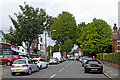
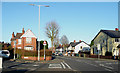
4
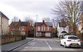
Lyndhurst Road Junction
The view of the junction with Lea Road in Merridale, Wolverhampton.
Image: © Gordon Griffiths
Taken: 1 Feb 2018
0.04 miles
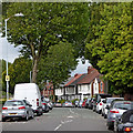
5
Jeffcock Road
The view in Penn Fields, Wolverhampton.
Image: © Gordon Griffiths
Taken: 25 Feb 2018
0.04 miles
6
Jeffcock Road in Penn Fields, Wolverhampton
Looking north-north-west towards Bantock Park, from near the junction with Lea Road.
Image: © Roger Kidd
Taken: 10 Sep 2020
0.06 miles
7
Jeffcock Road in Penn Fields, Wolverhampton
Looking north-north-west towards Bantock Park, from near the junction with Lea Road.
Image: © Roger Kidd
Taken: 10 Sep 2020
0.06 miles
8
Jeffcock Road in Penn Fields, Wolverhampton
Looking north-north-west towards Bantock Park.
Image: © Roger Kidd
Taken: 10 Sep 2020
0.06 miles
9
Lea Road in Penn Fields, Wolverhampton
Looking north towards the city centre from near the Stubbs Road junction.
Image: © Roger Kidd
Taken: 10 Sep 2020
0.06 miles
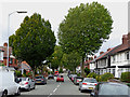
10
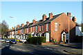
Lea Road, Penn Fields, Wolverhampton
This is the junction with Jeffcock Road (left), which goes north-north-west towards Merridale. The housing is mainly early 20th century, a mixture of terraced and semi-detached buildings. The population in the area is multi-cultural, and Lea Road still has many corner shops and other small family run shops on its way to joining the Penn Road near the Wolverhampton Ring Road.
Image: © Roger D Kidd
Taken: 26 Dec 2008
0.06 miles