IMAGES TAKEN NEAR TO
Norfolk Road, WOLVERHAMPTON, WV3 0JB
Introduction
This page details the photographs taken nearby to Norfolk Road, WV3 0JB by members of the Geograph project.
The Geograph project started in 2005 with the aim of publishing, organising and preserving representative images for every square kilometre of Great Britain, Ireland and the Isle of Man.

There are currently over 7.5m images from over14,400 individuals and you can help contribute to the project by visiting https://www.geograph.org.uk
Image Map
Images are licensed for reuse under creativecommons.org/licenses/by-sa/2.0
Notes
- Clicking on the map will re-center to the selected point.
- The higher the marker number, the further away the image location is from the centre of the postcode.
Image Listing (138 Images Found)
Images are licensed for reuse under creativecommons.org/licenses/by-sa/2.0
Image
Details
Distance
1
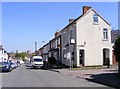
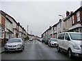
Rayleigh Road View
The view by Norfolk Road in Merridale, Wolverhampton.
Image: © Gordon Griffiths
Taken: 5 May 2018
0.03 miles
2
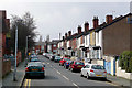
Aston Street Junction
The view down Norfolk Road in Bradmore, Wolverhampton.
Image: © Gordon Griffiths
Taken: 5 May 2018
0.03 miles
3
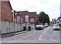
Aston Street, Penn Fields, Wolverhampton
Looking towards Owen Street from the junction with Norfolk Street. On the skyline is the tower of St Peter's Church in Wolverhampton city centre. The brick wall on the right hides the grounds of the former Bingley Junior and Infant School, built c 1910. This is now the Bingley Enterprise Centre.
Image: © Roger D Kidd
Taken: 17 Mar 2010
0.03 miles
4
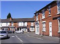
Lowest section of Rayleigh Road, Penn Fields
Image: © Richard Vince
Taken: 6 Jun 2013
0.03 miles
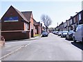
5
Rayleigh Road
The view in Merridale, Wolverhampton.
Image: © Gordon Griffiths
Taken: 3 Feb 2018
0.05 miles
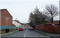
6
Aston Street, Penn Fields, Wolverhampton
Aston Street climbs from Owen Road to Norfolk Street. The early 20th century terraced houses here are clearly slightly "higher class" than some of the smaller ones lower down to the east. Quite apart from being a little more spacious, they have front bay downstairs windows. Parking is a obvious problem.
Image: © Roger D Kidd
Taken: 17 Mar 2010
0.06 miles
7
Aston Street
The view from Owen Road in Penn Fields, Wolverhampton.
Image: © Gordon Griffiths
Taken: 10 Aug 2017
0.06 miles
8
Bamford Road
The view towards Rayleigh Road in Bradmore, Wolverhampton.
Image: © Gordon Griffiths
Taken: 5 May 2018
0.06 miles
9

Bingley Street, Penn Fields, Wolverhampton
Owen Road is at the bottom of the slope. St Peter's Church tower in the city centre can be seen on the skyline.
Image: © Roger D Kidd
Taken: 17 Mar 2010
0.07 miles
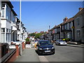
10
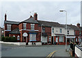
Owen Road, Penn Fields, Wolverhampton
This is at the junction with Aston Street. The area contains mainly early 20th or late Victorian terraced housing. The community is racially very mixed. Many corner shops still thrive, and other premises also support a variety of small businesses. The one in this image specialises in ladies', gents' and children's clothing.
Image: © Roger D Kidd
Taken: 17 Mar 2010
0.08 miles