IMAGES TAKEN NEAR TO
Lime Street, WOLVERHAMPTON, WV3 0EX
Introduction
This page details the photographs taken nearby to Lime Street, WV3 0EX by members of the Geograph project.
The Geograph project started in 2005 with the aim of publishing, organising and preserving representative images for every square kilometre of Great Britain, Ireland and the Isle of Man.

There are currently over 7.5m images from over14,400 individuals and you can help contribute to the project by visiting https://www.geograph.org.uk
Image Map
Images are licensed for reuse under creativecommons.org/licenses/by-sa/2.0
Notes
- Clicking on the map will re-center to the selected point.
- The higher the marker number, the further away the image location is from the centre of the postcode.
Image Listing (157 Images Found)
Images are licensed for reuse under creativecommons.org/licenses/by-sa/2.0
Image
Details
Distance
1
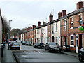
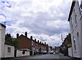
Terraced houses in Lime Street, Penn Fields, Wolverhampton
Late Victorian terraced housing in the Penn Fields area is gradually being modernised with new windows and roofs. Some missing chimney stacks over replaced roofs indicate that central heating has been installed. One of the scourges of the early 21st century is the ramp across the road - for "traffic calming". Woe betide anyone on a bicycle when the road is icy or partly covered in snow.
Image: © Roger D Kidd
Taken: 8 Dec 2009
0.01 miles
2
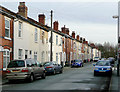
Terraced houses in Lime Street, Penn Fields, Wolverhampton
Solid late Victorian terraced housing in the Penn Fields area is gradually being modernised with new windows and roofs. Some missing chimney stacks over replaced roofs indicate that central heating has been installed. The junction with Cardiff Street is a few metres ahead. The area is home to a varied multi-ethnic community.
Image: © Roger D Kidd
Taken: 8 Dec 2009
0.02 miles
3
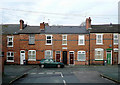
Terraced housing in Lime Street, Wolverhampton
Late Victorian terraced housing in the Penn Fields area. Modern windows, new roofs, and missing chimney stacks (indicating central heating is installed) are commonplace in the area.
Image: © Roger D Kidd
Taken: 8 Dec 2009
0.03 miles
4
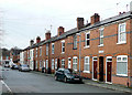
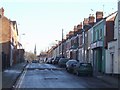
Lime Street, Penn Fields, Wolverhampton
Looking towards the junction with Owen Road. Late Victorian terraced housing in the Penn Fields area. Modern windows, new roofs, and missing chimney stacks (indicating central heating is installed) are commonplace in the area.
Image: © Roger D Kidd
Taken: 8 Dec 2009
0.03 miles
5
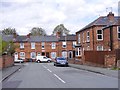
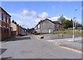
Cardiff Street
The view from Lime Street in Penn Fields, Wolverhampton.
Image: © Gordon Griffiths
Taken: 1 May 2018
0.04 miles
6
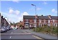
Manlove Street
The view towards Lime Street in Penn Fields, Wolverhampton.
Image: © Gordon Griffiths
Taken: 1 May 2018
0.04 miles
7
Kimberley Street Junction
The view of the junction with Merridale Street West in Wolverhampton.
Image: © Gordon Griffiths
Taken: 26 Apr 2018
0.05 miles
8
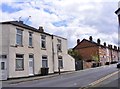
Private Housing - Merridale Street West
Dating from the 1870s and 1880s as the town expanded rapidly. St Johns church marks the edge of the town.
Image: © John M
Taken: 3 Jan 2010
0.05 miles
9
Ashland street Junction
The view of the junction with Merridale Street in Wolverhampton.
Image: © Gordon Griffiths
Taken: 26 Apr 2018
0.07 miles
10
Bristol Street
The view from Lime Street in Penn Fields, Wolverhampton.
Image: © Gordon Griffiths
Taken: 1 May 2018
0.08 miles