IMAGES TAKEN NEAR TO
Bromford Rise, WOLVERHAMPTON, WV3 0ET
Introduction
This page details the photographs taken nearby to Bromford Rise, WV3 0ET by members of the Geograph project.
The Geograph project started in 2005 with the aim of publishing, organising and preserving representative images for every square kilometre of Great Britain, Ireland and the Isle of Man.

There are currently over 7.5m images from over14,400 individuals and you can help contribute to the project by visiting https://www.geograph.org.uk
Image Map
Images are licensed for reuse under creativecommons.org/licenses/by-sa/2.0
Notes
- Clicking on the map will re-center to the selected point.
- The higher the marker number, the further away the image location is from the centre of the postcode.
Image Listing (258 Images Found)
Images are licensed for reuse under creativecommons.org/licenses/by-sa/2.0
Image
Details
Distance
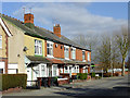
1
Bromford Road
The view in Merridale, Wolverhampton.
Image: © Gordon Griffiths
Taken: 5 May 2018
0.02 miles
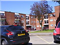
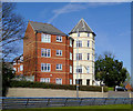
2
Flats on Penn Road
These flats, between Lea road and Penn Road, were built on land previously occupied by the Mount, and Y.W.C.A.
Image: © Annette Randle
Taken: 25 Aug 2007
0.02 miles
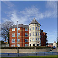
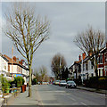
3
Penn Road Flats
The view across the dual carriageway in Wolverhampton.
Image: © Gordon Griffiths
Taken: 5 Nov 2017
0.04 miles
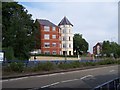
4
Apartments by Penn Road, Wolverhampton
The apartments are in Pennant Court, off the A449 Penn Road (northbound carriageway).
Image: © Roger D Kidd
Taken: 25 Mar 2017
0.05 miles
5
Apartments by Penn Road, Wolverhampton
The apartments are in Pennant Court, off the Penn Road (north carriageway).
Image: © Roger D Kidd
Taken: 25 Mar 2017
0.06 miles
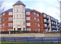
6
Apartments in Pennant Court, Wolverhampton
Pennant Court is off the A449 Penn Road (northbound carriageway) and was built in the early-mid 2000s on the site formerly occupied by the YMCA and The Mount (Wolverhampton Education Department).
Image: © Roger D Kidd
Taken: 25 Mar 2017
0.06 miles
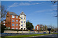
7
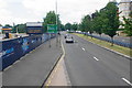
Penn Road
The A449 heading away from Wolverhampton. There is a development site on the left and Pennant Court on the right.
Image: © Bill Boaden
Taken: 22 Jun 2018
0.06 miles
9
Housing in Lea Road, Wolverhampton
This terrace on Lea Road is at the junction with Fern Road.
Image: © Roger D Kidd
Taken: 21 Feb 2013
0.07 miles
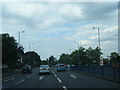
10
Lea Road in Penn Fields, Wolverhampton
Looking towards the city, near the junction with Bristol Street (off to the left).
Image: © Roger D Kidd
Taken: 21 Feb 2013
0.07 miles