IMAGES TAKEN NEAR TO
Penn Road, WOLVERHAMPTON, WV3 0DU
Introduction
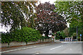
This page details the photographs taken nearby to Penn Road, WV3 0DU by members of the Geograph project.
The Geograph project started in 2005 with the aim of publishing, organising and preserving representative images for every square kilometre of Great Britain, Ireland and the Isle of Man.

There are currently over 7.5m images from over14,400 individuals and you can help contribute to the project by visiting https://www.geograph.org.uk
Image Map
Images are licensed for reuse under creativecommons.org/licenses/by-sa/2.0
Notes
- Clicking on the map will re-center to the selected point.
- The higher the marker number, the further away the image location is from the centre of the postcode.
Image Listing (215 Images Found)
Images are licensed for reuse under creativecommons.org/licenses/by-sa/2.0
Image
Details
Distance
1
Hindu Temple
The view of Shree Krishan Mandir temple on the Penn Road and Marston Road junction in Wolverhampton.
Image: © Gordon Griffiths
Taken: 1 Feb 2018
0.02 miles
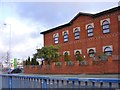
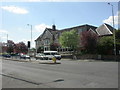
2
Wolverhampton Christadelphian Hall, Penn Road
Image: © Richard Law
Taken: 23 Dec 2009
0.02 miles
3
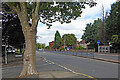
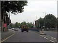
Penn Road in Blakenhall, Wolverhampton
Looking north-north-east towards Wolverhampton city centre.
Off to the left, Lonsdale Road leads north-west-ish towards Lea Road.
Image: © Roger Kidd
Taken: 26 Aug 2022
0.02 miles
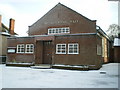
4
Penn Ambulance Station
The station stands in Marston Road.
Image: © Gordon Griffiths
Taken: 12 Apr 2008
0.02 miles
5
Penn Road (A449) - dual carriageway again
After the tedious section through Penn, a welcome return to a decently laid out road.
Image: © J Whatley
Taken: 6 Sep 2010
0.03 miles
6
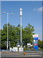
New transmitting pole in Penn Road, Wolverhampton
The tall white pole and its associated equipment boxes below have appeared in the last two months. I have yet to discover which mobile phone company owns it.
Don't expect to read the price* of fuel easily as you drive by. Tesco's brand experts are too interested in colour co-ordination to bother with actually making the prices clearly visible (except maybe at night). Waitrose weren't that silly.
* The prices are 129·9/130·9 for petrol/diesel.
Image: © Roger Kidd
Taken: 15 Sep 2021
0.03 miles
7
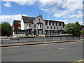
Hotel View
The view across Wolverhampton's Penn Road of the Goldthorn Hotel, due to be knocked down for a supermarket.
Image: © Gordon Griffiths
Taken: 14 Jun 2022
0.03 miles
8
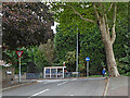
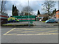
Penn Road near Blakenhall in Wolverhampton
The view of the A449 Penn Road is at the junction with Lonsdale Road.
Currently the bus stop is for routes 64 (Penn), 15 (Kingswinford and Merry Hill) and 16 (Stourbridge) southbound. Transport authorities have tampered with routes quite often in recent years!
Image: © Roger Kidd
Taken: 26 Aug 2022
0.03 miles
9
Lonsdale Road near Blakenhall in Wolverhampton
The view towards the A449 Penn Road is at the junction with Lonsdale Road.
Image: © Roger Kidd
Taken: 26 Aug 2022
0.03 miles
10
Wolverhampton, Goldthorn Hotel
On Penn Road, opposite the entrance to Image; hotel with associated leisure club & conference centre. The ground floor has some intricate plasterwork and wood panelling. http://www.hotels-wolverhampton.com/
Image: © Mike Faherty
Taken: 26 Apr 2009
0.04 miles