IMAGES TAKEN NEAR TO
Owen Road, WOLVERHAMPTON, WV3 0AN
Introduction
This page details the photographs taken nearby to Owen Road, WV3 0AN by members of the Geograph project.
The Geograph project started in 2005 with the aim of publishing, organising and preserving representative images for every square kilometre of Great Britain, Ireland and the Isle of Man.

There are currently over 7.5m images from over14,400 individuals and you can help contribute to the project by visiting https://www.geograph.org.uk
Image Map
Images are licensed for reuse under creativecommons.org/licenses/by-sa/2.0
Notes
- Clicking on the map will re-center to the selected point.
- The higher the marker number, the further away the image location is from the centre of the postcode.
Image Listing (145 Images Found)
Images are licensed for reuse under creativecommons.org/licenses/by-sa/2.0
Image
Details
Distance
1
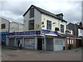
Newsagents and supermarket on Owen Road, Wolverhampton
Image: © JThomas
Taken: 22 Aug 2019
0.02 miles
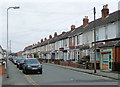
2
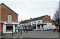
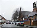
Owen Road, Penn Fields, Wolverhampton
At this junction Owen Road passes Lime Street (ahead to the right past the white-painted wall) and Rayleigh Road behind the camera.
The area contains mainly early 20th or late Victorian terraced housing. The community is racially very mixed. Many corner shops still thrive, and other premises also support a variety of small businesses. In this image, on the left is a trader in fresh or frozen meat, poultry and sea food. On the corner of Lime Street opposite is a corner grocer store, oops, I mean Superstore and off licence. In Owen road is a catering business and a hair/beauty/massage specialist, which I haven't tried yet ;-)
Image: © Roger D Kidd
Taken: 17 Mar 2010
0.02 miles
3
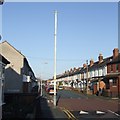
Sewer Vent Pipe - Owen Road
A tall locally listed example probably dating from the 1870 or 1880s manufactured by Ham Baker and Co Limited of Westminster.
Image: © John M
Taken: 3 Jan 2010
0.03 miles
4
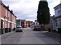
Owen Road Junction
The view of the junction with Merridale Street West in Wolverhampton.
Image: © Gordon Griffiths
Taken: 26 Apr 2018
0.03 miles
5
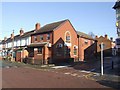
Owen Road Medical Centre, Penn Fields, Wooverhampton
Among hundreds of solidly built late Victorian and early 20th century terraced housing, with many small retail businesses scattered about, especially on corners, this new medical centre is at the junction with Merridale Street West.
Image: © Roger D Kidd
Taken: 17 Mar 2010
0.03 miles
6
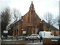
Owen Road Medical Centre
The air-conditioning units appear to be an afterthought.
Image: © John M
Taken: 3 Jan 2010
0.03 miles
7
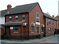
St Chad's Youth and Community Centre, Penn
On the corner of Owen Road and Lime Street (despite the sign in the foreground which talks about Rayleigh Road)
Image: © Richard Law
Taken: 23 Dec 2009
0.04 miles
8
Owen Road View
The view in Merridale, Wolverhampton.
Image: © Gordon Griffiths
Taken: 3 Feb 2018
0.04 miles
9
Owen Road, Penn Fields, Wolverhampton
This is Owen Road north of the junction with Merridale Road.
The area contains mainly early 20th or late Victorian terraced housing. The community is racially very mixed. Many corner shops still thrive, and other premises also support a variety of small businesses. In this image, there is an estate agent. The blue shuttered frontage further along the road was a sweetshop and tobacconist.
Image: © Roger D Kidd
Taken: 17 Mar 2010
0.04 miles
10
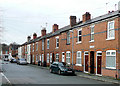
Lime Street, Penn Fields, Wolverhampton
Looking towards the junction with Owen Road. Late Victorian terraced housing in the Penn Fields area. Modern windows, new roofs, and missing chimney stacks (indicating central heating is installed) are commonplace in the area.
Image: © Roger D Kidd
Taken: 8 Dec 2009
0.04 miles