IMAGES TAKEN NEAR TO
The Haven, WOLVERHAMPTON, WV2 4LR
Introduction
This page details the photographs taken nearby to The Haven, WV2 4LR by members of the Geograph project.
The Geograph project started in 2005 with the aim of publishing, organising and preserving representative images for every square kilometre of Great Britain, Ireland and the Isle of Man.

There are currently over 7.5m images from over14,400 individuals and you can help contribute to the project by visiting https://www.geograph.org.uk
Image Map
Images are licensed for reuse under creativecommons.org/licenses/by-sa/2.0
Notes
- Clicking on the map will re-center to the selected point.
- The higher the marker number, the further away the image location is from the centre of the postcode.
Image Listing (207 Images Found)
Images are licensed for reuse under creativecommons.org/licenses/by-sa/2.0
Image
Details
Distance
1
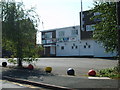
Billa's Bar
The pub stands on Dudley Road.
Image: © Gordon Griffiths
Taken: 28 Jul 2008
0.02 miles
2
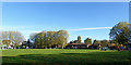
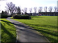
View east across Graiseley Park in Wolverhampton
The housing of The Haven can be seen ahead in Lower Villiers Street.
Image: © Roger Kidd
Taken: 2 Nov 2018
0.03 miles
3
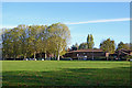
Graiseley Park in Wolverhampton
This is a pleasantly landscaped park (also called Graiseley Recreation Ground) hidden between older industrial premises and some late nineteenth and early twentieth century housing near Lower Villiers Street. The more modern housing called "The Haven" can be seen ahead.
Image: © Roger Kidd
Taken: 2 Nov 2018
0.03 miles
4
Graiseley Park in Wolverhampton
This is a pleasantly landscaped park (also called Graiseley Recreation Ground) hidden between older industrial premises and some late nineteenth and early twentieth century housing near Lower Villiers Street. A more modern housing development called "The Haven" can be seen ahead.
Image: © Roger Kidd
Taken: 2 Nov 2018
0.03 miles
5
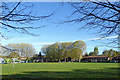
Park View
The view from Graiseley Recreation Ground in Blakenhall Wolverhampton.
Image: © Gordon Griffiths
Taken: 31 Jan 2013
0.04 miles
6
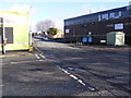
Drayton Street Junction
The view of Drayton Street and Lower Villiers Street next to Graiseley Recreation Ground in Blakenhall Wolverhampton.
Image: © Gordon Griffiths
Taken: 31 Jan 2013
0.04 miles
7

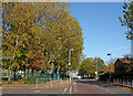
British Trolleybuses - Wolverhampton
By the time I visited Wolverhampton's trolleybus system, it was reduced to the long route 58 to Dudley. This view is noted as taken on Dudley Road. Modern aerial views have not enabled the location to be confirmed - there is no sign of a building now to match the chapel in the background - but I was reasonably sure that I had it correct, with the street to the right of the trolleybus being Johnson Street. Roger Kidd's up-to-date image http://www.geograph.org.uk/photo/568941 shows the same location some 40 years later.
For a slide show of British Trolleybuses in the late 60s http://www.geograph.org.uk/search.php?i=1773236&displayclass=slide
Image: © Alan Murray-Rust
Taken: 22 May 1966
0.06 miles
8
Lower Villiers Street in Wolverhampton
Off to the left is Fellows Street and Graiseley Park.
Image: © Roger Kidd
Taken: 2 Nov 2018
0.06 miles
9
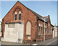
Pountney Street Methodist Church (Disused)
See http://www.wolvesmethodism.mikejackson.org.uk/Pountney%20Street/index.html
Image: © Mike Jackson
Taken: Unknown
0.06 miles
10
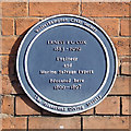
Ernest Frank Guelph Cox, Wolverhampton
Ernest Cox was responsible for finding many of the ships from the German High Seas Fleet that were scuttled in Scapa Flow on 17th June 1919. Out of the 74 ships that were interned at Scapa Flow, 51 were sunk and 43 of them subsequently raised. Only 8 still remain. The total weight of the ships that were sunk was over 400,000 tons. The largest salvage operation in history was soon underway and the Scapa Flow Salvage and Shipbreaking Company was formed in 1923, to raise some of the torpedo boats. Over the next 8 years he undertook a massive operation to raise the ships. It was to become one of the greatest feats of marine salvage ever accomplished. He purchased and modified an old German floating dry dock and lifted 26 torpedo boats, and broke them up for scrap in between August 1924 and April 1926.
...and there's more where that came from!! The text by Ian Jukes is copied from this superb account of his life http://www.localhistory.scit.wlv.ac.uk/plaques/DudleyRd2.htm .
Image: © Roger D Kidd
Taken: 9 Feb 2008
0.06 miles