IMAGES TAKEN NEAR TO
Pountney Street, WOLVERHAMPTON, WV2 4HX
Introduction
This page details the photographs taken nearby to Pountney Street, WV2 4HX by members of the Geograph project.
The Geograph project started in 2005 with the aim of publishing, organising and preserving representative images for every square kilometre of Great Britain, Ireland and the Isle of Man.

There are currently over 7.5m images from over14,400 individuals and you can help contribute to the project by visiting https://www.geograph.org.uk
Image Map (351 Images)

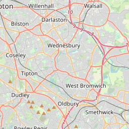


Leaflet Map data © OpenStreetMap
Images are licensed for reuse under creativecommons.org/licenses/by-sa/2.0
Notes
- Clicking on the map will re-center to the selected point.
- The higher the marker number, the further away the image location is from the centre of the postcode.
Image Listing (351 Images Found)
Images are licensed for reuse under creativecommons.org/licenses/by-sa/2.0
Image
Details
Distance
1
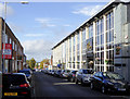
Pountney Street in Blakenhall, Wolverhampton
Looking east-north-east towards Ablow Street and the A449 (Penn Road). On the right is the Royale Banqueting Suite.
Image: © Roger D Kidd
Taken: 12 Oct 2017
0.01 miles
2
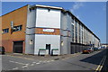
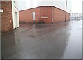
Royale Banqueting Suite
Industrial building with external and internal redecoration to convert to a banqueting suite. These are becoming a relatively common feature around the city catering primarily for marriage celebrations within the large Sikh community.
Image
Image: © John M
Taken: 12 May 2016
0.03 miles
3
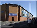
Site of Wearwell Works - Pountney Street
A modern factory building occupies the site. Wearwell were in the forefront of motorcycle manufacture in the early 1900s after dabbling with car building. They built motorcycles on this site until 1909 notably the Wolf. Engines were provided by the Stevens brothers. The failure of Wearwell prompted the Stevens brothers to set up the AJS factory on Retreat Street.
Image: © John M
Taken: 12 Sep 2009
0.03 miles
4
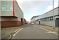
Pountney Street
The view in Blakenhall, Wolverhampton.
Image: © Gordon Griffiths
Taken: 11 Mar 2013
0.03 miles
5
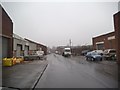
King Edwards Row
The view of an Industrial area off Pearson Street on a wet foggy day in Blakenhall, Wolverhampton.
Image: © Gordon Griffiths
Taken: 8 Mar 2013
0.04 miles
6
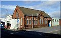
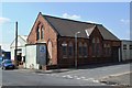
Former church in Thomas Street in Blakenhall, Wolverhampton
This is on the corner of Thomas Street and Pountney Street. The former church premises now houses the Roger Chetters vehicle maintenance workshops.
The Pountney Street Primitive Methodist Chapel building was opened in 1893 as a mission hall in the Darlington Street Wesleyan Methodist Circuit. It was closed for worship in 1949. Peter Hickman gives more information here: http://www.wolvesmethodism.mikejackson.org.uk/Pountney%20Street/Short%20History/index.html
Image: © Roger D Kidd
Taken: 12 Oct 2017
0.04 miles
7
Pearson Street
The view of an Industrial area on a wet foggy day in Blakenhall, Wolverhampton.
Image: © Gordon Griffiths
Taken: 8 Mar 2013
0.04 miles
8
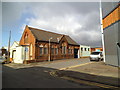
Thomas Street
The view of the former Wesleyan Methodist Mission Hall on the corner of Pountney Street in Blakenhall, Wolverhampton.
Image: © Gordon Griffiths
Taken: 11 Mar 2013
0.04 miles
9
Former Pountney Street Methodist Church
The congregation moved away from the area from the turn of the twentieth century as the area gave way to manufacturing. The church itself closed after the Second World War. It now appears to be used by the neighbouring garage.
Image: © John M
Taken: 12 May 2016
0.04 miles
10
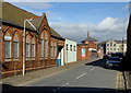
Thomas Street in Blakenhall, Wolverhampton
Looking north-north-west from the junction with Pountney Street.
Image: © Roger D Kidd
Taken: 12 Oct 2017
0.05 miles