IMAGES TAKEN NEAR TO
Thompson Avenue, WOLVERHAMPTON, WV2 3NY
Introduction
This page details the photographs taken nearby to Thompson Avenue, WV2 3NY by members of the Geograph project.
The Geograph project started in 2005 with the aim of publishing, organising and preserving representative images for every square kilometre of Great Britain, Ireland and the Isle of Man.

There are currently over 7.5m images from over14,400 individuals and you can help contribute to the project by visiting https://www.geograph.org.uk
Image Map
Images are licensed for reuse under creativecommons.org/licenses/by-sa/2.0
Notes
- Clicking on the map will re-center to the selected point.
- The higher the marker number, the further away the image location is from the centre of the postcode.
Image Listing (165 Images Found)
Images are licensed for reuse under creativecommons.org/licenses/by-sa/2.0
Image
Details
Distance
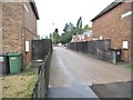
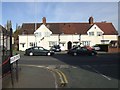
1
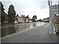
Thompson Avenue Scene
The view at the junction with Parkfield Crescent, Wolverhampton.
Image: © Gordon Griffiths
Taken: 4 Aug 2013
0.02 miles
2
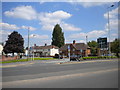
Former bus turning circle, Parkfield Crescent, Parkfield
For many years, Wolverhampton Corporation's Thompson Avenue bus service (numbered variously 14, 15, 34, and latterly 97) used this turning circle built into the west end of Parkfield Crescent. This route was something of a dead end for Wolverhampton Corporation: south of this point Thompson Avenue becomes Birmingham New Road, which was constructed in the late 1920s and was always Midland Red territory until its Birmingham and Black Country operations were purchased by West Midlands Passenger Transport Executive (which absorbed Wolverhampton Corporation's buses in 1969) in 1973.
Image: © Richard Vince
Taken: 3 Jun 2013
0.02 miles
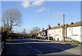
3
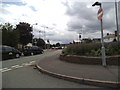
Parkfield Crescent
The view at the junction with Thompson Avenue in Parkfield, Wolverhampton.
Image: © Gordon Griffiths
Taken: 30 Jul 2013
0.02 miles
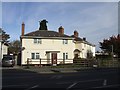
4
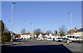
Thompson Avenue in Parkfield, Wolverhampton
This is where Birmingham New Road (A4123) approaching Wolverhampton (off to the left) crosses the A4089, and continues as Thompson Avenue, bending round to the left. The housing ahead and to the right is in Parkfield Crescaent.
Image: © Roger D Kidd
Taken: 11 Feb 2016
0.03 miles
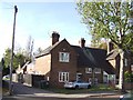
5
Barnard Place
The view from Thompson Avenue in Wolverhampton.
Image: © Gordon Griffiths
Taken: 4 Aug 2013
0.03 miles
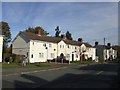
6
Council Housing - Thompson Avenue
Early 1920s council housing on the Parkfield Estate. More properties are packed in behind in Barnard Place.
Image: © John M
Taken: 30 Oct 2010
0.04 miles
7
Council Housing - Parkfield Crescent
The shortage of available land within the borough was a constraint to the advent of organised council house building. The Parkfield Estate was built in the early 1920s on the former Parkfield Colliery site.
Council house sales under 'Right to Buy' show up with modifications to properties either by owners or improvements by the council. The abandoned sofa suggests a council property.
Image: © John M
Taken: 30 Oct 2010
0.04 miles
8
Thompson Avenue in Parkfield, Wolverhampton
This is the A4123 from Birmingham on its way towards Wolverhampton city centre.
Image: © Roger D Kidd
Taken: 11 Feb 2016
0.04 miles
9
Council Housing - Parkfield Road
Early houses on the Parkfield Estate. The plaques have the council coat of arms dated 1920.
Image: © John M
Taken: 30 Oct 2010
0.04 miles
10
Council Housing - Parkfield Road/Thompson Avenue
Linked properties on the corner of Parkfield Road and Thompson Avenue. The date plaque and coat of arms shows the building was constructed in 1920. This marks the start of the major council house building programme which followed the Great War. The Parkfield Estate was built on the former Parkfield Colliery.
Image: © John M
Taken: 30 Oct 2010
0.04 miles