IMAGES TAKEN NEAR TO
Cooke Street, WOLVERHAMPTON, WV2 3AD
Introduction
This page details the photographs taken nearby to Cooke Street, WV2 3AD by members of the Geograph project.
The Geograph project started in 2005 with the aim of publishing, organising and preserving representative images for every square kilometre of Great Britain, Ireland and the Isle of Man.

There are currently over 7.5m images from over14,400 individuals and you can help contribute to the project by visiting https://www.geograph.org.uk
Image Map
Images are licensed for reuse under creativecommons.org/licenses/by-sa/2.0
Notes
- Clicking on the map will re-center to the selected point.
- The higher the marker number, the further away the image location is from the centre of the postcode.
Image Listing (202 Images Found)
Images are licensed for reuse under creativecommons.org/licenses/by-sa/2.0
Image
Details
Distance
1
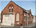
Pountney Street Methodist Church (Disused)
See http://www.wolvesmethodism.mikejackson.org.uk/Pountney%20Street/index.html
Image: © Mike Jackson
Taken: Unknown
0.02 miles
2
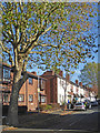
Housing in Mason Street, Wolverhampton
Looking east, Mason Street links Lower Villers Street with Dudley Road.
Image: © Roger Kidd
Taken: 2 Nov 2018
0.04 miles
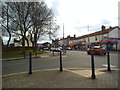
3
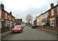
Mason Street
The view in Blakenhall, Wolverhampton.
Image: © Gordon Griffiths
Taken: 12 Mar 2013
0.05 miles
4
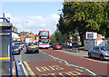
Dudley Road, Wolverhampton - Forty Years on
No trolley buses operate on the Dudley Road forty years later. Please compare this image with Image]
The Methodist Chapel and all the housing on the right has gone, and the terrace this side of the trolley bus has been replaced by a small grassy area with trees. These trees must be not far short of forty years old, so demolition must have taken place soon after the 1966 picture was taken. The “Grinding” firm is now a tyre fitting operation (which I think has expanded a few metres north from its 1967 position to take advantage of some of the released land).
In the middle distance, new housing is set back from the road. The road, which was wide in 1966, has been narrowed down in recent months to provide designated parking bays, and pavements have been built out into the former road space to accommodate larger bus shelters without blocking the pavement. Consequently, the number 558 bus (replacing the number 58 trolley bus in Alan’s picture) passing Johnson Street is pushed right out to the middle of what was a wide carriageway. A red car is parked where the trolley bus was passing by forty years earlier.
The red brick building in the distance is the former Dudley Road Primary School; the building in front of it is ready for demolition; both are visible in the 1966 photograph.
Image: © Roger D Kidd
Taken: 29 Sep 2007
0.05 miles
5
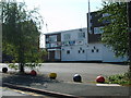
Billa's Bar
The pub stands on Dudley Road.
Image: © Gordon Griffiths
Taken: 28 Jul 2008
0.05 miles
6
Dudley Road Scene
The view on the A459 in Blakenhall Wolverhampton.
Image: © Gordon Griffiths
Taken: 14 Mar 2013
0.06 miles
7
Lower Villiers Street in Wolverhampton
Off to the left is Fellows Street and Graiseley Park.
Image: © Roger Kidd
Taken: 2 Nov 2018
0.06 miles
8
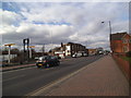
Dudley Road
The view from the corner of Johnson Street down the A459 in Blakenhall Wolverhampton.
Image: © Gordon Griffiths
Taken: 14 Mar 2013
0.06 miles
9
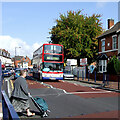
Pedestrian crossing in Dudley Road, Wolverhampton
Beep-beep-beep-beep ...
Looking north, terraced housing is on the right, and three storey shops and housing is off to the left.
The bus is a Transbus Trident new to West Midlands Travel (Fleet No 4595) in 2004.
Image: © Roger Kidd
Taken: 29 Sep 2007
0.06 miles
10
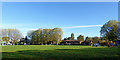
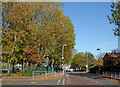
View east across Graiseley Park in Wolverhampton
The housing of The Haven can be seen ahead in Lower Villiers Street.
Image: © Roger Kidd
Taken: 2 Nov 2018
0.06 miles