Dudley Road, Wolverhampton - Forty Years on
Introduction
The photograph on this page of Dudley Road, Wolverhampton - Forty Years on by Roger D Kidd as part of the Geograph project.
The Geograph project started in 2005 with the aim of publishing, organising and preserving representative images for every square kilometre of Great Britain, Ireland and the Isle of Man.

There are currently over 7.5m images from over 14,400 individuals and you can help contribute to the project by visiting https://www.geograph.org.uk
Dudley Road, Wolverhampton - Forty Years on
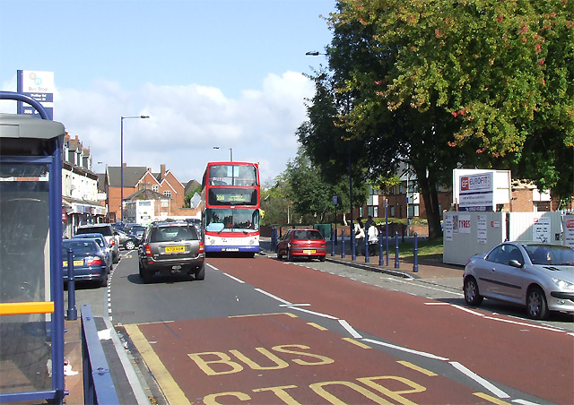
Image: © Roger D Kidd Taken: 29 Sep 2007
No trolley buses operate on the Dudley Road forty years later. Please compare this image with Image] The Methodist Chapel and all the housing on the right has gone, and the terrace this side of the trolley bus has been replaced by a small grassy area with trees. These trees must be not far short of forty years old, so demolition must have taken place soon after the 1966 picture was taken. The “Grinding” firm is now a tyre fitting operation (which I think has expanded a few metres north from its 1967 position to take advantage of some of the released land). In the middle distance, new housing is set back from the road. The road, which was wide in 1966, has been narrowed down in recent months to provide designated parking bays, and pavements have been built out into the former road space to accommodate larger bus shelters without blocking the pavement. Consequently, the number 558 bus (replacing the number 58 trolley bus in Alan’s picture) passing Johnson Street is pushed right out to the middle of what was a wide carriageway. A red car is parked where the trolley bus was passing by forty years earlier. The red brick building in the distance is the former Dudley Road Primary School; the building in front of it is ready for demolition; both are visible in the 1966 photograph.
Images are licensed for reuse under creativecommons.org/licenses/by-sa/2.0
Image Location
Latitude
52.57543
Longitude
-2.126268