IMAGES TAKEN NEAR TO
George Street, WOLVERHAMPTON, WV2 2PA
Introduction
This page details the photographs taken nearby to George Street, WV2 2PA by members of the Geograph project.
The Geograph project started in 2005 with the aim of publishing, organising and preserving representative images for every square kilometre of Great Britain, Ireland and the Isle of Man.

There are currently over 7.5m images from over14,400 individuals and you can help contribute to the project by visiting https://www.geograph.org.uk
Image Map
Images are licensed for reuse under creativecommons.org/licenses/by-sa/2.0
Notes
- Clicking on the map will re-center to the selected point.
- The higher the marker number, the further away the image location is from the centre of the postcode.
Image Listing (121 Images Found)
Images are licensed for reuse under creativecommons.org/licenses/by-sa/2.0
Image
Details
Distance
1
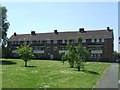
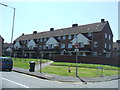
Council Housing - Junction Road
A set of three storey blocks dating from 1950s arranged around grassy courtyard.
Image: © John M
Taken: 6 Jun 2013
0.03 miles
2
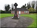
Freezeland Cenotaph
The view from George Street Wolverhampton.
Image: © Gordon Griffiths
Taken: 13 Nov 2010
0.03 miles
3
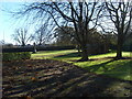
Freezeland Park
The view from George Street, Wolverhampton.
Image: © Gordon Griffiths
Taken: 13 Nov 2010
0.04 miles
4
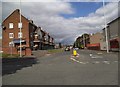
Ward Street
The view from Hall Park Street, Wolverhampton.
Image: © Gordon Griffiths
Taken: 8 Sep 2013
0.04 miles
6
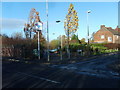
Junction Road
The view from George Street, Bilston.
Image: © Gordon Griffiths
Taken: 13 Nov 2010
0.05 miles
7
Council Housing - Ward Street
A set of three storey blocks dating from 1950s arranged around grassy courtyard.
Image: © John M
Taken: 6 Jun 2013
0.05 miles
8
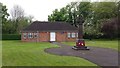
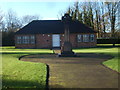
Memorial Hall
The memorial Hall sits in a quiet garden on George Street, Priestfield.
Image: © Peter Mackenzie
Taken: 12 May 2017
0.05 miles
9
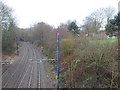
Priestfield railway station (site), West Midlands
Opened in 1854 by the Great Western Railway and its constituents, on the lines from Wolverhampton to Birmingham Snow Hill and Dudley, this station closed in 1972.
View south east. This was a junction station with 2 platforms curving left towards Birmingham (which had become the Midland Metro when this image was taken) and two curving right towards Dudley (through a cutting that has now been infilled).
See http://www.disused-stations.org.uk/p/priestfield/index.shtml for more details.
Image: © Nigel Thompson
Taken: 24 Jan 2018
0.06 miles
10
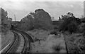
Overgrown and derelict remains of Priestfield Station. 1978.
Overgrown and derelict remains of Priestfield Station, 1978. The former GWR tracks, still in situ at this time, curved away towards Bilston Central and Birmingham (Snow Hill) whilst those formerly serving the West Midland Line platforms (closed 1962) once led in the direction of Bilston West and, eventually, Stourbridge Junction. Note the ex GWR ATC ramp still in place on the Wolverhampton line at the bottom of the picture. The former GWR line had closed to passenger traffic in 1972 and was later reopened as the Midland Metro, Wolverhampton (St George's) to Birmingham (Snow Hill).
Image: © Tim Marshall
Taken: 26 Oct 1978
0.06 miles