IMAGES TAKEN NEAR TO
Victor Close, WOLVERHAMPTON, WV2 2NY
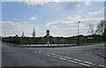
Introduction
This page details the photographs taken nearby to Victor Close, WV2 2NY by members of the Geograph project.
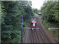
The Geograph project started in 2005 with the aim of publishing, organising and preserving representative images for every square kilometre of Great Britain, Ireland and the Isle of Man.

There are currently over 7.5m images from over14,400 individuals and you can help contribute to the project by visiting https://www.geograph.org.uk
Image Map
Images are licensed for reuse under creativecommons.org/licenses/by-sa/2.0
Notes
- Clicking on the map will re-center to the selected point.
- The higher the marker number, the further away the image location is from the centre of the postcode.
Image Listing (134 Images Found)
Images are licensed for reuse under creativecommons.org/licenses/by-sa/2.0
Image
Details
Distance
1
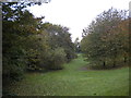
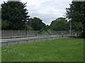
Open space off Ward Street, Priestfield
Occupying the site of the western platforms of Priestfield railway station, which were on the former Oxford, Worcester & Wolverhampton Railway line towards Dudley.
Image: © Richard Vince
Taken: 20 Oct 2018
0.03 miles
2
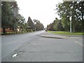
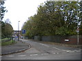
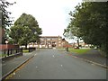
Ward Street Scene
The view from Sidwick Crescent, Ettingshall, Bilston.
Image: © Gordon Griffiths
Taken: 12 Aug 2013
0.04 miles
3
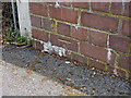
OS benchmark - Ward Street railway bridge
Cutmark low in the brickwork of the bridge which now crosses the Metro line from Wolverhampton to Birmingham. Levelled at a height of 140.5707m, 461'2" above Ordnance Datum Newlyn.
Image: © Richard Law
Taken: 2 Aug 2013
0.04 miles
4
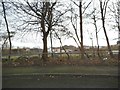
Site of Priestfield Station on the disused Stourbridge to Wolverhampton (Low Level) line
Now an open space next to the Midland Metro this was once a junction between GWRs Snow Hill and Stourbridge lines. The station closed in 1972. The new tram stop on the former Snow Hill line is around 400m closer to Wolverhampton.
Image: © John M
Taken: 12 Jul 2008
0.05 miles
5
Wolverhampton bound tram at site of old Priestfield Station
The modern tram stop on the Midland Metro is about 400m nearer to Wolverhampton.
Image: © John M
Taken: 12 Jul 2008
0.05 miles
6
Line of disused Stourbridge to Wolverhampton (Low Level) line
The line branched off from the Snow Hill line at Priestfield Station and became disused from early 1960s. The bridges at Ward Street and John Street are in-filled though the ends are marked by the brick pilasters and vertical chevrons. Ground level in the cutting has been raised by many metres.
Image: © John M
Taken: 12 Jul 2008
0.05 miles
7
North side of Sidwick Crescent, Priestfield
Seen from Ward Street. Sidwick Crescent crosses the site of the western platforms of Priestfield railway station, which were on the former Oxford, Worcester & Wolverhampton Railway line towards Dudley.
Image: © Richard Vince
Taken: 20 Oct 2018
0.05 miles
8
Crescent View
The view of new housing alongside the Birmingham Canal from Sidwick Crescent, Ettingshall, Bilston.
Image: © Gordon Griffiths
Taken: 27 Jan 2014
0.05 miles
9
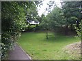
Ward Street Park
The view in Bilston.
Image: © Gordon Griffiths
Taken: 20 Apr 2022
0.06 miles
10
Sidwick Crescent Flats
The view in Ettingshall, Bilston.
Image: © Gordon Griffiths
Taken: 12 Aug 2013
0.06 miles