IMAGES TAKEN NEAR TO
Granville Close, WOLVERHAMPTON, WV2 1EQ
Introduction
This page details the photographs taken nearby to Granville Close, WV2 1EQ by members of the Geograph project.
The Geograph project started in 2005 with the aim of publishing, organising and preserving representative images for every square kilometre of Great Britain, Ireland and the Isle of Man.

There are currently over 7.5m images from over14,400 individuals and you can help contribute to the project by visiting https://www.geograph.org.uk
Image Map
Images are licensed for reuse under creativecommons.org/licenses/by-sa/2.0
Notes
- Clicking on the map will re-center to the selected point.
- The higher the marker number, the further away the image location is from the centre of the postcode.
Image Listing (288 Images Found)
Images are licensed for reuse under creativecommons.org/licenses/by-sa/2.0
Image
Details
Distance
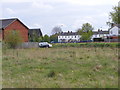
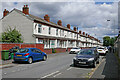
1
Granville Close
A Close off Granville Street near Wolverhampton City.
Image: © Gordon Griffiths
Taken: 25 Mar 2012
0.02 miles
2
Gordon Street Scene
The view down the Wolverhampton Street behind the former Royal Hospital.
Image: © Gordon Griffiths
Taken: 15 Apr 2011
0.05 miles
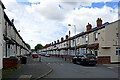
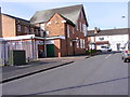
3
Maxwell Road in Wolverhampton
Maxwell Road is now a cul-de-sac leading from Vicarage Road to Adelaide Walk, Gower Street and playing fields at All Saints Park. This is the view eastwards.
Image: © Roger Kidd
Taken: 26 Jun 2023
0.05 miles
4
City Wasteland
The view from Gordon Street, Wolverhampton.
Image: © Gordon Griffiths
Taken: 15 Apr 2011
0.06 miles
5
Maxwell Road in Wolverhampton
Maxwell Road is now a cul-de-sac leading to Adelaide Walk, Gower Street and playing fields at All Saints Park. This is the view westwards towards Vicarage Road.
Image: © Roger Kidd
Taken: 26 Jun 2023
0.06 miles
6
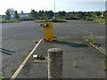
Derelict Car Park
The now closed Royal Hospital car park.
Image: © Gordon Griffiths
Taken: 19 Sep 2008
0.06 miles
7
Maxwell Road
A Road off Vicarage Road near Wolverhampton City.
Image: © Gordon Griffiths
Taken: 25 Mar 2012
0.06 miles
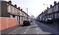
8
Maxwell Road in Wolverhampton
Maxwell Road is now a cul-de-sac leading to Adelaide Walk, Gower Street and playing fields at All Saints Park. This is the view eastwards from Vicarage Road.
Image: © Roger Kidd
Taken: 26 Jun 2023
0.06 miles
9
Dartmouth Street
A Close off Vicarage Road near Wolverhampton City.
Image: © Gordon Griffiths
Taken: 25 Mar 2012
0.06 miles