IMAGES TAKEN NEAR TO
Adelaide Walk, WOLVERHAMPTON, WV2 1DX
Introduction
This page details the photographs taken nearby to Adelaide Walk, WV2 1DX by members of the Geograph project.
The Geograph project started in 2005 with the aim of publishing, organising and preserving representative images for every square kilometre of Great Britain, Ireland and the Isle of Man.

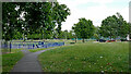
There are currently over 7.5m images from over14,400 individuals and you can help contribute to the project by visiting https://www.geograph.org.uk
Image Map
Images are licensed for reuse under creativecommons.org/licenses/by-sa/2.0
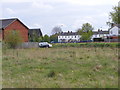
Notes
- Clicking on the map will re-center to the selected point.
- The higher the marker number, the further away the image location is from the centre of the postcode.
Image Listing (225 Images Found)
Images are licensed for reuse under creativecommons.org/licenses/by-sa/2.0
Image
Details
Distance
1
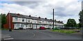
Terraced housing at Adelaide Walk in Wolverhampton
This row of terraced houses in Adelaide Walk (originally Adelaide Street) is close to All Saints Park. There used to be more terraces to their right, plus some industrial building (now all demolished) as far as Steelhouse Lane. That area is now part of All Saints Park.
Image: © Roger Kidd
Taken: 26 Jun 2023
0.00 miles
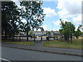
2
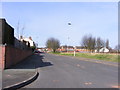
Granville Street
A Street off Vicarage Road near Wolverhampton City.
Image: © Gordon Griffiths
Taken: 25 Mar 2012
0.02 miles
3
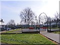
Maxwell Road Playground
The view of the play area on Maxwell Road near Wolverhampton City.
Image: © Gordon Griffiths
Taken: 25 Mar 2012
0.02 miles
4
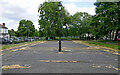
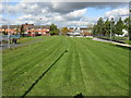
Former recreational area near All Saints in Wolverhampton
This dilapidated space is between the terraced housing rows of Adelaide Walk and Gower Street, and is directly linked to All Saints Park. Larger scale maps describe it as a "Sports Facility".
In 2012 it appeared to be functioning as a simple but neatly maintained playground area, see Image
Image: © Roger Kidd
Taken: 26 Jun 2023
0.02 miles
5
Public open space and playgrounds off All Saints Road
Image: © Peter Whatley
Taken: 22 Oct 2008
0.03 miles
6
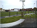
Seat View
The view from the play park in All Saints, Wolverhampton.
Image: © Gordon Griffiths
Taken: 16 Nov 2013
0.03 miles
7
All Saints Playground
The view off Steelhouse Lane, Wolverhampton.
Image: © Gordon Griffiths
Taken: 29 Jun 2010
0.04 miles
8
New housing at the end of Graham Road
Image: © Peter Whatley
Taken: 22 Oct 2008
0.04 miles
9
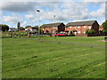
All Saints Park in Wolverhampton
Looking east towards Steelhouse Lane, the Adelaide Play Park is on the left. Gower Street is off to the right.
Image: © Roger Kidd
Taken: 26 Jun 2023
0.04 miles
10
City Wasteland
The view from Gordon Street, Wolverhampton.
Image: © Gordon Griffiths
Taken: 15 Apr 2011
0.04 miles