IMAGES TAKEN NEAR TO
Tempest Street, WOLVERHAMPTON, WV2 1AA
Introduction
This page details the photographs taken nearby to Tempest Street, WV2 1AA by members of the Geograph project.
The Geograph project started in 2005 with the aim of publishing, organising and preserving representative images for every square kilometre of Great Britain, Ireland and the Isle of Man.

There are currently over 7.5m images from over14,400 individuals and you can help contribute to the project by visiting https://www.geograph.org.uk
Image Map
Images are licensed for reuse under creativecommons.org/licenses/by-sa/2.0
Notes
- Clicking on the map will re-center to the selected point.
- The higher the marker number, the further away the image location is from the centre of the postcode.
Image Listing (938 Images Found)
Images are licensed for reuse under creativecommons.org/licenses/by-sa/2.0
Image
Details
Distance
1
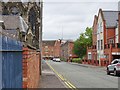
Tempest Street
The view alongside the street by the former St Mary and St John's School at Snow Hill, Wolverhampton.
Image: © Gordon Griffiths
Taken: 16 Aug 2019
0.01 miles
2
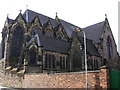
Catholic Church View
The view of St Mary and St John Church from Tempest Street Wolverhampton.
Image: © Gordon Griffiths
Taken: 1 Dec 2015
0.02 miles
3
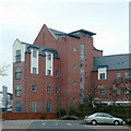
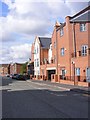
New Apartments by Ring Road St George's, Wolverhampton
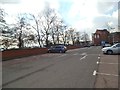
Looking down on Sainsbury's car park and the ring road, this part of the regeneration of the city centre was completed in 2008. I wonder what the air is like in and around traffic heavy places like this, though I suppose most of the people will be away somewhere else at work while the daytime pollution is at its heaviest.
It has now been given a typically "trendy" name: "The Curve".
Image: © Roger D Kidd
Taken: 29 Dec 2008
0.02 miles
4
Tempest Street Church
The back view of St Mary and St John Church from Tempest Street Wolverhampton.
Image: © Gordon Griffiths
Taken: 1 Dec 2015
0.03 miles
5
Tempest Street View
The view past new apartments down to Wolverhampton Central Library.
Image: © Gordon Griffiths
Taken: 12 Aug 2010
0.03 miles
6
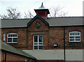
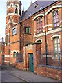
St George's Veterinary Hospital, Wolverhampton
A detail from the building at the rear of the practice. The front of the complex is of Georgian origin. Image]
Image: © Roger D Kidd
Taken: 31 Mar 2009
0.03 miles
7
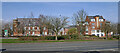
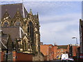
View towards Tempest Street in Wolverhampton
Looking north across Ring Road St George's, towards Tempest Street. On the left is the former Saint Mary and Saint John's Catholic School dating from 1869. On the right is The Curve apartment development, dating from 2007-2008.
Image: © Roger Kidd
Taken: 22 Mar 2022
0.04 miles
8
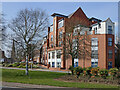
Apartments by Ring Road St George's in Wolverhampton
This is The Curve development (2007-2008), accessed via Tempest Street. I have often wondered why people choose to live by a such very busy road, with all its air pollution. It can't be healthy.
Image: © Roger Kidd
Taken: 22 Mar 2022
0.04 miles
9
Sainsbury's Car Park View
The view alongside Wolverhampton Ring Road.
Image: © Gordon Griffiths
Taken: 17 Mar 2013
0.04 miles
10
Girls Only
The former school is now used by St Mary and St John's Church.
Image: © Gordon Griffiths
Taken: 20 Nov 2008
0.04 miles