IMAGES TAKEN NEAR TO
Chetton, BRIDGNORTH, WV16 6UF
Introduction
This page details the photographs taken nearby to WV16 6UF by members of the Geograph project.
The Geograph project started in 2005 with the aim of publishing, organising and preserving representative images for every square kilometre of Great Britain, Ireland and the Isle of Man.

There are currently over 7.5m images from over14,400 individuals and you can help contribute to the project by visiting https://www.geograph.org.uk
Image Map
Images are licensed for reuse under creativecommons.org/licenses/by-sa/2.0
Notes
- Clicking on the map will re-center to the selected point.
- The higher the marker number, the further away the image location is from the centre of the postcode.
Image Listing (7 Images Found)
Images are licensed for reuse under creativecommons.org/licenses/by-sa/2.0
Image
Details
Distance
1
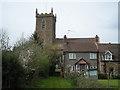
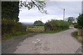
Footpath to St Giles
The house on the far right used to be the village pub. Called 'The Old Inn' it was a lovely place, very quiet though. Presumably that's why it closed to the public in 1996.
Image: © Row17
Taken: 26 Apr 2008
0.08 miles
3
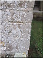
Ordnance Survey Cut Mark
This OS cut mark can be found on St Giles Church. It marks a point 201.270m above mean sea level.
Image: © Adrian Dust
Taken: 26 Nov 2015
0.10 miles
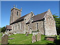
6
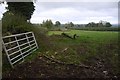
Farmland in Chetton
There is little up here, but the church suggests that this is one of the many lost or diminished villages on the high ground around the Clee Hills and Bromyard. The long narrow field suggests antiquity too.
Image: © Richard Webb
Taken: 16 Oct 2018
0.20 miles
7
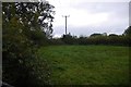
Field, Upper House
Small fields survive here.
Image: © Richard Webb
Taken: 16 Oct 2018
0.22 miles