IMAGES TAKEN NEAR TO
Underton, BRIDGNORTH, WV16 6TY
Introduction
This page details the photographs taken nearby to Underton, WV16 6TY by members of the Geograph project.
The Geograph project started in 2005 with the aim of publishing, organising and preserving representative images for every square kilometre of Great Britain, Ireland and the Isle of Man.

There are currently over 7.5m images from over14,400 individuals and you can help contribute to the project by visiting https://www.geograph.org.uk
Image Map
Images are licensed for reuse under creativecommons.org/licenses/by-sa/2.0
Notes
- Clicking on the map will re-center to the selected point.
- The higher the marker number, the further away the image location is from the centre of the postcode.
Image Listing (6 Images Found)
Images are licensed for reuse under creativecommons.org/licenses/by-sa/2.0
Image
Details
Distance
1
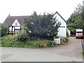
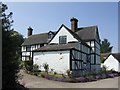
Underton Cottage
C17 timber framed and brick cottage with tiled roof. listed Grade II.
Image: © Eirian Evans
Taken: 23 Aug 2019
0.04 miles
2
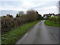
In Underton village
The hamlet basically consists of East & West Farms, and a handful of cottages & bungalows, most of which are of more recent vintage than the farms.
Image: © Richard Law
Taken: 2 Dec 2012
0.05 miles
3
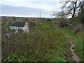
West Farm house from the bridleway above it
The sign on the building actually calls itself Orchard House, but it appears to be the farmhouse belonging to the nearby West Farm. The bridleway currently has a drainage 'issue', resulting in very wet conditions underfoot.
Image: © Richard Law
Taken: 2 Dec 2012
0.06 miles
4
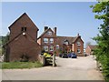
East Farm, Underton
Obviously now converted to residential use unlike the nearby West Farm.
Image: © John M
Taken: 5 May 2007
0.07 miles
5
West Farm House
Large farmhouse in the small hamlet of Underton. The working farm is a short distance away.
Image: © John M
Taken: 5 May 2007
0.08 miles
6
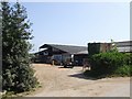
West Farm
A busy farmyard with tractors and equipment.
Image: © John M
Taken: 5 May 2007
0.14 miles