IMAGES TAKEN NEAR TO
Beech Green, BRIDGNORTH, WV16 6RU
Introduction
This page details the photographs taken nearby to Beech Green, WV16 6RU by members of the Geograph project.
The Geograph project started in 2005 with the aim of publishing, organising and preserving representative images for every square kilometre of Great Britain, Ireland and the Isle of Man.

There are currently over 7.5m images from over14,400 individuals and you can help contribute to the project by visiting https://www.geograph.org.uk
Image Map
Images are licensed for reuse under creativecommons.org/licenses/by-sa/2.0
Notes
- Clicking on the map will re-center to the selected point.
- The higher the marker number, the further away the image location is from the centre of the postcode.
Image Listing (29 Images Found)
Images are licensed for reuse under creativecommons.org/licenses/by-sa/2.0
Image
Details
Distance
1
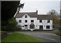
The Pheasant Inn
Although closed at the time of taking this photograph the pub re-opens for business under local community ownership on 6th November 2014. I'll have to give it a try.
Image: © Row17
Taken: 3 Nov 2008
0.02 miles
2
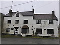
The Pheasant Inn, Neenton, Shropshire
A roadside pub that is no longer trading by the look of things. Shame.
Update: I have been informed that the pub is now owned by the local community and re-opens on the 6th November 2014! Great news. I will be dropping in for lunch...
Image: © Jeremy Bolwell
Taken: 30 Jan 2014
0.05 miles
3
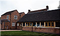
The Pheasant Inn, Neenton, Shropshire
Newly re-opened as a community owned pub, The Pheasant Inn at Neenton
Image: © Nick Comley
Taken: 23 Oct 2014
0.05 miles
4
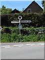
Old Direction Sign - Signpost by the B4364, Neenton Parish
Annulus finial - 2 arms; Shropshire CC halo by the B4364, opposite The Pheasant Inn in parish of Neenton (Bridgnorth District).
Surveyed
Milestone Society National ID: SA_SO6387.
Image: © Milestone Society
Taken: Unknown
0.06 miles
5
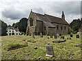
All Saints church (Neenton)
Like the parish church at Cleobury North (a mile southwest from here), Neenton parish church is another familiar sight to drivers on the B4364 road (Bridgnorth to Ludlow). It was built from 1870-71 by Sir Arthur Blomfield, and one of the stained glass windows was designed by Morris and Co. in 1922. The Pheasant Inn is behind the churchyard to the left of this view, and the pub successfully reopened ten years ago.
Image: © Fabian Musto
Taken: 12 Jul 2024
0.06 miles
6
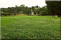
Field, Neenton
A view from the car park at "The Pheasant", and a fine crop of white clover in the field. In the background, road signs indicate priority over oncoming traffic as the B4364 crosses the Rea Brook.
Image: © Derek Harper
Taken: 28 Jul 2019
0.06 miles
7
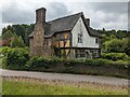
Churchyard House (Neenton)
Viewed from the churchyard at All Saints parish church (hence the name of the house), this grade II* listed house was built at the turn of the late C16, and it was altered from every century onwards. The timber-framed house is rendered on the upper storey of the west façade, and it has looked like that for several decades; the B4364 road is in the middle ground.
Image: © Fabian Musto
Taken: 12 Jul 2024
0.07 miles
8
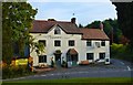
The Pheasant Inn, Neenton
Owned by the community and definitely foody. A small door round the corner bears the sign 'Locals Bar'.
Image: © Philip Pankhurst
Taken: 19 Sep 2015
0.07 miles
9
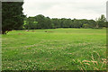
Rea Brook valley
Looking right from Image], again with white clover. Across the fields, trees line the stream.
Image: © Derek Harper
Taken: 28 Jul 2019
0.07 miles
10
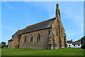
All Saints Church, Neenton
On ancient foundations, but mainly by A.W. Blomfield in 1870-1. In the village centre on an elevated site.
Image: © Philip Pankhurst
Taken: 19 Sep 2015
0.07 miles