IMAGES TAKEN NEAR TO
Faintree, BRIDGNORTH, WV16 6RQ
Introduction
This page details the photographs taken nearby to WV16 6RQ by members of the Geograph project.
The Geograph project started in 2005 with the aim of publishing, organising and preserving representative images for every square kilometre of Great Britain, Ireland and the Isle of Man.

There are currently over 7.5m images from over14,400 individuals and you can help contribute to the project by visiting https://www.geograph.org.uk
Image Map
Images are licensed for reuse under creativecommons.org/licenses/by-sa/2.0
Notes
- Clicking on the map will re-center to the selected point.
- The higher the marker number, the further away the image location is from the centre of the postcode.
Image Listing (5 Images Found)
Images are licensed for reuse under creativecommons.org/licenses/by-sa/2.0
Image
Details
Distance
2
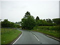
B4364 approaching Winterburn Brook crossing
The B road swoops down to cross the stream before climbing to Faintree Hall. The wood on the other side is Lower Coppice, in Image Image was taken from the gate on the left.
Image: © Derek Harper
Taken: 26 Jul 2019
0.14 miles
3
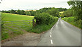
Field, Faintree
Beside the very twisty Bridgnorth to Ludlow road.
Image: © Richard Webb
Taken: 13 Apr 2016
0.15 miles
4
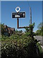
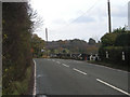
Old Direction Sign - Signpost by the B4364, Faintree, Chetton Parish
Annulus finial - 1 Worboys arm; Shropshire CC modern halo by the B4364, in parish of Chetton (Bridgnorth District), Faintree.
Surveyed
Milestone Society National ID: SA_SO6588
Image: © Milestone Society
Taken: Unknown
0.22 miles