IMAGES TAKEN NEAR TO
Astbury, BRIDGNORTH, WV16 6AT
Introduction
This page details the photographs taken nearby to Astbury, WV16 6AT by members of the Geograph project.
The Geograph project started in 2005 with the aim of publishing, organising and preserving representative images for every square kilometre of Great Britain, Ireland and the Isle of Man.

There are currently over 7.5m images from over14,400 individuals and you can help contribute to the project by visiting https://www.geograph.org.uk
Image Map
Images are licensed for reuse under creativecommons.org/licenses/by-sa/2.0
Notes
- Clicking on the map will re-center to the selected point.
- The higher the marker number, the further away the image location is from the centre of the postcode.
Image Listing (48 Images Found)
Images are licensed for reuse under creativecommons.org/licenses/by-sa/2.0
Image
Details
Distance
1
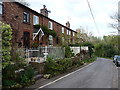
Cottages at Upper Forge
A terrace of cottages, presumably once homes to workers at the former foundry and ironworks at Upper Forge. This was one of a pair, in conjunction with the industry at Image, which was operated by the Pemberton and Stokes company between 1789 and about 1814. Ownership changed over the years, and Lower Forge continued in business until the 1880s, although it seems likely that Upper Forge had ceased to be viable well before that date.
Image: © Richard Law
Taken: 19 Apr 2015
0.02 miles
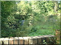
2
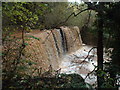
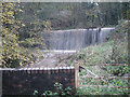
Weir for Eardington Upper Forge
This is on the Mor Brook and is a masonry dam 30 yards long and raising the water level by 15'. Sluices supplied the Upper Forge and the tail race from there constituted a navigable canal and water supply to the Lower Forge. This is the most spectacular publicly accessible remnant of the Upper Forge as the other remains are in a trout farm and not accessible. The pond behind the dam/weir is now very largely silted up. The forges made fine charcoal iron for gun barrels, wire and horseshoe nails.
Image: © Chris Hodrien
Taken: 10 Nov 2019
0.06 miles
3
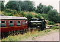
Eardington station
A former GWR tank heads a train north towards Bridgnorth, through what is now a disused station.
Image: © Roger Cornfoot
Taken: Unknown
0.06 miles
6
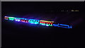
GWR No. 2857 with 'Steam in Lights' at Eardington
New Christmas special that was announced by the Severn Valley Railway in November 2019, the steam locomotive and its train is basically covered in just Christmas decorations... how epic is that? The engine pulling this excellent special was GWR No. 2857.
Image: © Fabian Musto
Taken: 7 Dec 2019
0.19 miles
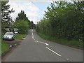
8
Permissive footpath and horse shelter
The path on this side of the gate is permissive but there is a public footpath on the other side leading down towards the Severn Valley Railway. The track is seen on the left centre of this photograph.
Image: © Chris Allen
Taken: 13 May 2021
0.19 miles
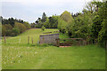
9
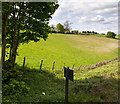
Fields by the railway
Looking WNW from the Severn Valley Railway over the adjoining green fields.
Image: © David P Howard
Taken: 15 May 2014
0.20 miles
10
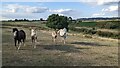
Horses at Eardington Bank
These four friendly horses approached us as we were walking down to see the final train of the day (at the Severn Valley Railway).
Image: © Fabian Musto
Taken: 31 Aug 2022
0.20 miles