IMAGES TAKEN NEAR TO
Glazeley, BRIDGNORTH, WV16 6AB
Introduction
This page details the photographs taken nearby to WV16 6AB by members of the Geograph project.
The Geograph project started in 2005 with the aim of publishing, organising and preserving representative images for every square kilometre of Great Britain, Ireland and the Isle of Man.

There are currently over 7.5m images from over14,400 individuals and you can help contribute to the project by visiting https://www.geograph.org.uk
Image Map
Images are licensed for reuse under creativecommons.org/licenses/by-sa/2.0
Notes
- Clicking on the map will re-center to the selected point.
- The higher the marker number, the further away the image location is from the centre of the postcode.
Image Listing (13 Images Found)
Images are licensed for reuse under creativecommons.org/licenses/by-sa/2.0
Image
Details
Distance
2
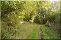
Mill Coppice
Woodland on steep slopes where a brook cuts down to the level of the Severn.
Image: © Richard Webb
Taken: 9 Oct 2017
0.08 miles
3
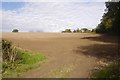
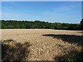
Seedbed
Recently cultivated field, probably winter cereals.
Image: © Richard Webb
Taken: 9 Oct 2017
0.11 miles
6
Ripe wheat east of Glazeley
Several days of good weather have brought the local wheat crop to a fine, ripe condition. This field overlooks the Borle Brook valley, with Mill Coppice on the far side.
Image: © Richard Law
Taken: 15 Aug 2016
0.20 miles
7

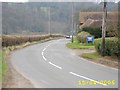
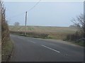
B4363 at Glazeley war memorial
The phone box was still extant when we passed, but it's just out of sight to the right.
Image: © Peter Whatley
Taken: 23 Mar 2012
0.21 miles
8
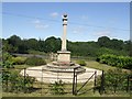
War Memorial
The war memorial stands in the corner of the churchyard.
Image: © John M
Taken: 25 Aug 2007
0.22 miles
10
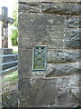
OS Flush Bracket - Glazeley church
Flush Bracket S9668 affixed to the north wall of the church; originally levelled in 1959 at 102.542m above Ordnance Datum Newlyn.
Image: © Richard Law
Taken: 15 Aug 2016
0.23 miles