IMAGES TAKEN NEAR TO
Tining Close, BRIDGNORTH, WV16 5PE
Introduction
This page details the photographs taken nearby to Tining Close, WV16 5PE by members of the Geograph project.
The Geograph project started in 2005 with the aim of publishing, organising and preserving representative images for every square kilometre of Great Britain, Ireland and the Isle of Man.

There are currently over 7.5m images from over14,400 individuals and you can help contribute to the project by visiting https://www.geograph.org.uk
Image Map
Images are licensed for reuse under creativecommons.org/licenses/by-sa/2.0
Notes
- Clicking on the map will re-center to the selected point.
- The higher the marker number, the further away the image location is from the centre of the postcode.
Image Listing (18 Images Found)
Images are licensed for reuse under creativecommons.org/licenses/by-sa/2.0
Image
Details
Distance
1
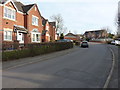
Housing on Harley Way
Built in the last few years, this area is prime contender for the highest housing in Bridgnorth.
Image: © Richard Law
Taken: 22 Mar 2015
0.03 miles
2
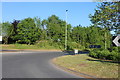
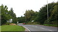
Ludlow Road View
The view on the Bridgnorth road near the A458 junction.
Image: © Gordon Griffiths
Taken: 9 Oct 2012
0.11 miles
3
Housing in Ludlow Heights
Very nearly the highest homes in Bridgnorth, the Ludlow Heights area has recently been usurped by new developments on the other side of the main road from here. But only just by a few feet.
Image: © Richard Law
Taken: 22 Mar 2015
0.13 miles
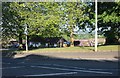
6
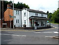
The Toll House, Westgate, Bridgnorth
Located at the NE end of Ludlow Road, at the Wenlock Road and Westgate junction. The house is probably much altered since it was last used as a toll house. Tolls on turnpike roads were abolished in the UK in 1872, after which the roads were maintained by local authorities.
Image: © Jaggery
Taken: 2 Jul 2014
0.14 miles
8
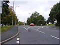
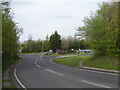
The roundabout on the A458 with Ludlow Road
We are stopped while walkers doing a 22mile walk pass by.
Image: © Ian S
Taken: 30 May 2011
0.15 miles
9
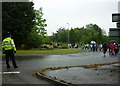
Approaching the roundabout
View at the end of the B4364 with road signs obscured by vegetation.
Image: © Peter Whatley
Taken: 29 Aug 2015
0.15 miles
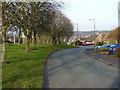
10
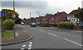
Portman's Way, Bridgnorth
Looking south from the corner of Three Ashes Road.
Image: © Jaggery
Taken: 2 Jul 2014
0.15 miles