IMAGES TAKEN NEAR TO
Castlefields, BRIDGNORTH, WV16 5DQ
Introduction
This page details the photographs taken nearby to Castlefields, WV16 5DQ by members of the Geograph project.
The Geograph project started in 2005 with the aim of publishing, organising and preserving representative images for every square kilometre of Great Britain, Ireland and the Isle of Man.

There are currently over 7.5m images from over14,400 individuals and you can help contribute to the project by visiting https://www.geograph.org.uk
Image Map
Images are licensed for reuse under creativecommons.org/licenses/by-sa/2.0
Notes
- Clicking on the map will re-center to the selected point.
- The higher the marker number, the further away the image location is from the centre of the postcode.
Image Listing (9 Images Found)
Images are licensed for reuse under creativecommons.org/licenses/by-sa/2.0
Image
Details
Distance
1
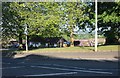
Castlefields Primary School
In a residential area with open fields behind the buildings.
Image: © John M
Taken: 5 May 2007
0.00 miles
2
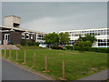
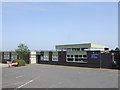
Oldbury Wells School - the west portion
The school is built on either side of Oldbury Wells Lane, and the children spend a good proportion of the day walking back and forth between the two sites. To be fair, they're only 50 yards apart, but it still takes as long as it takes.
Image: © Richard Law
Taken: 26 May 2010
0.11 miles
3

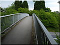
Footbridge over Bridgnorth by-pass (A458)
The footpath that crosses the bridge follows field boundaries on each side of the A458; the bridge is about 50 metres west of the line of these boundaries, so the path runs behind the trees on each side of this picture
Image: © David Smith
Taken: 23 Jul 2013
0.19 miles
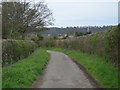
5
Footbridge over the Bridgnorth bypass
Part of NCN 45; the bridge was built to take foot traffic over the bypass when that cut the nearby Oldbury Wells Lane in half, and prevented access from the southwest.
Image: © Richard Law
Taken: 26 May 2010
0.20 miles
6
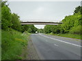
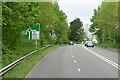
The bypass and the footbridge
Bridgnorth bypass, looking uphill on the 'racetrack' section, where the bikes regularly top the ton.
Image: © Richard Law
Taken: 26 May 2010
0.20 miles
8
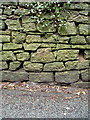
OS benchmark - Bridgnorth, Oldbury Wells wall
OS cutmark in the stone wall on the northwest side of Oldbury Wells Lane; originally levelled at 56.656m above Ordnance Datum Newlyn.
Image: © Richard Law
Taken: 25 Jan 2014
0.25 miles