IMAGES TAKEN NEAR TO
Rosehill Drive, BRIDGNORTH, WV16 5BP
Introduction
This page details the photographs taken nearby to Rosehill Drive, WV16 5BP by members of the Geograph project.
The Geograph project started in 2005 with the aim of publishing, organising and preserving representative images for every square kilometre of Great Britain, Ireland and the Isle of Man.

There are currently over 7.5m images from over14,400 individuals and you can help contribute to the project by visiting https://www.geograph.org.uk
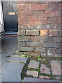
Image Map
Images are licensed for reuse under creativecommons.org/licenses/by-sa/2.0
Notes
- Clicking on the map will re-center to the selected point.
- The higher the marker number, the further away the image location is from the centre of the postcode.
Image Listing (75 Images Found)
Images are licensed for reuse under creativecommons.org/licenses/by-sa/2.0
Image
Details
Distance
2
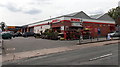
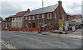
Spar store and Halfords Autocentre in Bridgnorth
On the south side of the B4364 Salop Street.
Image: © Jaggery
Taken: 2 Jul 2014
0.11 miles
3
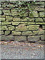
OS benchmark - Bridgnorth, Oldbury Wells wall
OS cutmark in the stone wall on the northwest side of Oldbury Wells Lane; originally levelled at 56.656m above Ordnance Datum Newlyn.
Image: © Richard Law
Taken: 25 Jan 2014
0.11 miles
4
House construction on the south side of Salop Street, Bridgnorth
Viewed in early July 2014.
Image: © Jaggery
Taken: 2 Jul 2014
0.14 miles
5
Ordnance Survey Cut Mark
This OS cut mark can be found on No25 Salop Street. It marks a point 69.586m above mean sea level.
Image: © Adrian Dust
Taken: 26 Nov 2015
0.14 miles
6
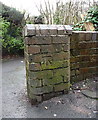
OS benchmark - Bridgnorth, junction of Rose Lane & The Yards
An OS cutmark in a brick pillar bounding the south side of the narrow path known as Rose Lane, which connects Hollybush Lane to Oldbury Wells. The mark was originally levelled at 56.056m above Ordnance Datum Newlyn.
Image: © Richard Law
Taken: 25 Jan 2014
0.14 miles
7
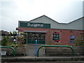
Budgens (Bridgnorth)
And I thought all Budgens stores were closed in the UK in 2017... turned out I was wrong all along. This Budgens store at Bridgnorth is somehow still open, and replaced a Spar store in the mid 2010's.
Image: © Fabian Musto
Taken: 8 Sep 2018
0.14 miles
8
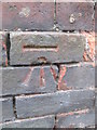
OS benchmark, Bridgnorth, 25 Salop Street
An OS cutmark in the bricks of no 25 Salop Street, which is coincidentally now the offices of a firm of consulting Structural Engineers and Surveyors. So they should certainly know what it is... Originally levelled at 69.586m above Ordnance Datum Newlyn.
Image: © Richard Law
Taken: 25 Jan 2014
0.14 miles
9
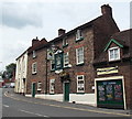
The Bell & Talbot, Bridgnorth
Pub in Salop Street, viewed from the corner of Pound Street. The name sign depicts a white talbot,
a large breed of hound with long hanging ears and heavy jaws. Now extinct, talbots were used for tracking and hunting.
Image: © Jaggery
Taken: 2 Jul 2014
0.16 miles