IMAGES TAKEN NEAR TO
Stanley Lane, BRIDGNORTH, WV16 4SR
Introduction
This page details the photographs taken nearby to Stanley Lane, WV16 4SR by members of the Geograph project.
The Geograph project started in 2005 with the aim of publishing, organising and preserving representative images for every square kilometre of Great Britain, Ireland and the Isle of Man.

There are currently over 7.5m images from over14,400 individuals and you can help contribute to the project by visiting https://www.geograph.org.uk
Image Map
Images are licensed for reuse under creativecommons.org/licenses/by-sa/2.0
Notes
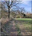
- Clicking on the map will re-center to the selected point.
- The higher the marker number, the further away the image location is from the centre of the postcode.
Image Listing (24 Images Found)
Images are licensed for reuse under creativecommons.org/licenses/by-sa/2.0
Image
Details
Distance
2
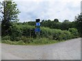
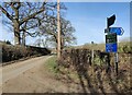
Signpost, Stanley Lane
A road here connects Stanley Lane with the trackbed of the Severn Valley Railway (the non preserved bit north of Bridgnorth). The old railway is used by local residents as a road and the National Cycle Network. Any hope of reopening the line and connecting the preserved railway south of Bridgnorth with Ironbridge are pretty well dashed by the building of a housing estate across the route in Bridgnorth.
Image: © Richard Webb
Taken: 30 Jun 2014
0.02 miles
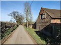
3
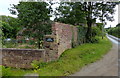
Little Severn Hall
Near to the river north of Bridgnorth. I would not have liked to meet one of these caravans coming up the very narrow lane.
Image: © John M
Taken: 28 Apr 2007
0.02 miles
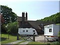
4
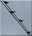
Four Swallows
On some telephone wires near Little Severn Hall.
Image: © Mat Fascione
Taken: 1 Aug 2017
0.02 miles
9
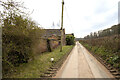
The inaccessible part of the old railway
The former GWR line north of here, between Coalport and Bridgnorth, has been (unofficially) used for years by walkers, horseriders and cyclists, but was recently opened by the Apley and Willey Estates as part of NCN45. However, this short section leading southwards in the general direction of the golf course remains closed to all; it kind of peters out as it runs into the golf course anyway.
Image: © Richard Law
Taken: 26 Feb 2012
0.07 miles