IMAGES TAKEN NEAR TO
Muckley Cross, BRIDGNORTH, WV16 4RP
Introduction
This page details the photographs taken nearby to Muckley Cross, WV16 4RP by members of the Geograph project.
The Geograph project started in 2005 with the aim of publishing, organising and preserving representative images for every square kilometre of Great Britain, Ireland and the Isle of Man.

There are currently over 7.5m images from over14,400 individuals and you can help contribute to the project by visiting https://www.geograph.org.uk
Image Map
Images are licensed for reuse under creativecommons.org/licenses/by-sa/2.0
Notes
- Clicking on the map will re-center to the selected point.
- The higher the marker number, the further away the image location is from the centre of the postcode.
Image Listing (9 Images Found)
Images are licensed for reuse under creativecommons.org/licenses/by-sa/2.0
Image
Details
Distance
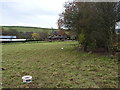
3

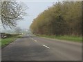
Farmland near Muckley Cross
Looking east.
Image: © David Medcalf
Taken: 14 Sep 2006
0.12 miles
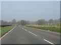
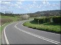
5
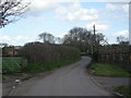
Cottage at Muckley Cross
A particularly fine rural cottage and its outbuildings, just off the A458 road.
Image: © Richard Law
Taken: 7 Dec 2013
0.18 miles
8
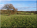
Footpath towards Hawthorne Farm
A row of old oak trees and a ditch mark the line of a former hedge, now followed by a path from Muckley Cross to Hawthorne Farm.
Image: © Richard Law
Taken: 7 Dec 2013
0.21 miles