IMAGES TAKEN NEAR TO
Salop Street, BRIDGNORTH, WV16 4QU
Introduction
This page details the photographs taken nearby to Salop Street, WV16 4QU by members of the Geograph project.
The Geograph project started in 2005 with the aim of publishing, organising and preserving representative images for every square kilometre of Great Britain, Ireland and the Isle of Man.

There are currently over 7.5m images from over14,400 individuals and you can help contribute to the project by visiting https://www.geograph.org.uk
Image Map
Images are licensed for reuse under creativecommons.org/licenses/by-sa/2.0
Notes
- Clicking on the map will re-center to the selected point.
- The higher the marker number, the further away the image location is from the centre of the postcode.
Image Listing (399 Images Found)
Images are licensed for reuse under creativecommons.org/licenses/by-sa/2.0
Image
Details
Distance
1
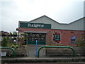
Budgens (Bridgnorth)
And I thought all Budgens stores were closed in the UK in 2017... turned out I was wrong all along. This Budgens store at Bridgnorth is somehow still open, and replaced a Spar store in the mid 2010's.
Image: © Fabian Musto
Taken: 8 Sep 2018
0.02 miles
3
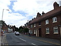
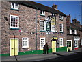
The Bell & Talbot, Bridgnorth
Pub in Salop Street, viewed from the corner of Pound Street. The name sign depicts a white talbot,
a large breed of hound with long hanging ears and heavy jaws. Now extinct, talbots were used for tracking and hunting.
Image: © Jaggery
Taken: 2 Jul 2014
0.02 miles
6
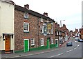
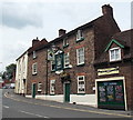
The Bell and Talbot (1), 2 Salop Street
A popular pub in the High Town area of Bridgnorth, it has two bars, one of which hosts live music every Friday and Sunday evening. The pub is one of three owned by Odley Inns Limited in Shropshire. It was at one time a coaching inn, but apparently in 1831 it was used as a wet-fish shop. The 1871 census shows a Talbott Inn (spelt with a double "t" at the end), in Salop Street, which presumably is this building. The innkeeper was a Richard Evans.
Since this pub was previously photographed for GeoGraph, it has been repainted, at ground floor level, with the external woodwork green, instead of yellow.
Image
Image
Image: © P L Chadwick
Taken: 6 Jul 2010
0.03 miles
7
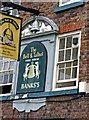
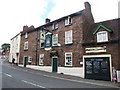
The Bell and Talbot (2) - detail, 2 Salop Street
The building is believed to be early 19th century, and is Grade II listed. The name is rather strange as there are two Talbot hounds depicted. According to a GeoGraph member, the connection between a Talbot hound and a bell arises from the tale of a french lord, de Talbot, who was a great hunting man. He bred his own type of hound, a large heavy dog, often with a spotted coat. It was not the done thing to hunt on the Sabbath, but de Talbot spotted a stag, and sent his hounds after it as the church bell tolled for the service. When de Talbot caught the stag, its antlers turned to a cross. de Talbot fell to his knees and vowed to become a priest. He eventually became a bishop and on his death was made a saint.
Alternatively, the name may have been given if two next door pubs were amalgamated, as there was a Tabott (not Talbot) Inn in Salop Street in 1871. The stucco panel shown here has an unusual moulded relief of a bell, with a dog on both sides.
Image
Image
Image: © P L Chadwick
Taken: 6 Jul 2010
0.03 miles
8
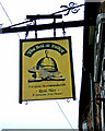
The Bell and Talbot (3) - sign, 2 Salop Street
It used to be a Banks's house, but is now a free house. The sign shows one Tabot hound, but the front wall has two.
Image
Image
Image: © P L Chadwick
Taken: 6 Jul 2010
0.03 miles
9
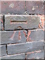
Ordnance Survey Cut Mark
This OS cut mark can be found on No25 Salop Street. It marks a point 69.586m above mean sea level.
Image: © Adrian Dust
Taken: 26 Nov 2015
0.03 miles
10
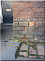
OS benchmark, Bridgnorth, 25 Salop Street
An OS cutmark in the bricks of no 25 Salop Street, which is coincidentally now the offices of a firm of consulting Structural Engineers and Surveyors. So they should certainly know what it is... Originally levelled at 69.586m above Ordnance Datum Newlyn.
Image: © Richard Law
Taken: 25 Jan 2014
0.03 miles