IMAGES TAKEN NEAR TO
Claremont Drive, BRIDGNORTH, WV16 4LE
Introduction
This page details the photographs taken nearby to Claremont Drive, WV16 4LE by members of the Geograph project.
The Geograph project started in 2005 with the aim of publishing, organising and preserving representative images for every square kilometre of Great Britain, Ireland and the Isle of Man.

There are currently over 7.5m images from over14,400 individuals and you can help contribute to the project by visiting https://www.geograph.org.uk
Image Map
Images are licensed for reuse under creativecommons.org/licenses/by-sa/2.0
Notes
- Clicking on the map will re-center to the selected point.
- The higher the marker number, the further away the image location is from the centre of the postcode.
Image Listing (42 Images Found)
Images are licensed for reuse under creativecommons.org/licenses/by-sa/2.0
Image
Details
Distance
2
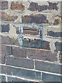
OS benchmark - Bridgnorth, no 28 Victoria Road
OS cutmark in the brickwork at the side of no 28 Victoria Road; originally levelled at 76.779m above Ordnance Datum Newlyn.
Image: © Richard Law
Taken: 7 Dec 2013
0.07 miles
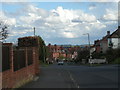
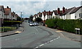
5
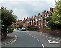
Victoria Road, Bridgnorth
Houses at the southern end of Victoria Road, viewed from the B4364 Salop Street.
Image: © Jaggery
Taken: 2 Jul 2014
0.12 miles
6
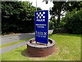
Bridgnorth Police Station name sign
On the corner of Wenlock Road and The Wheatlands, on the north side of the station. http://www.geograph.org.uk/photo/4065765
Image: © Jaggery
Taken: 2 Jul 2014
0.13 miles
7
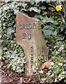
Old Milepost by the old A458, Wenlock Road, Bridgnorth parish
Cast iron post by the UC road (was A458), in parish of BRIDGNORTH (BRIDGNORTH District), by house gate entrance West of junction with the B4364, Westgate, on South side of road. Erected by the Bridgnorth Morvill turnpike trust in the 19th century. Broken.
Inscription reads:-
: SALOP / 20 / (vertical) TO THE COUNT.. : : B(RIDGNORTH / ½) / (vertical) TO THE TO.. :
Shropshire HER.
HER Number (PRN): 21101. https://www.heritagegateway.org.uk/Gateway/Results_Single.aspx?uid=MSA23671&resourceID=1015
Milestone Society National ID: SA_SBBN20.
Image: © A Reade/M Faherty
Taken: 8 Feb 2008
0.14 miles
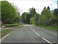
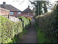
10
The Hookfield, Bridgnorth
Looking SW along The Hookfield from the corner of Innage Lane and Queensway Drive.
Image: © Jaggery
Taken: 2 Jul 2014
0.14 miles