IMAGES TAKEN NEAR TO
Greenfields Road, BRIDGNORTH, WV16 4JT
Introduction
This page details the photographs taken nearby to Greenfields Road, WV16 4JT by members of the Geograph project.
The Geograph project started in 2005 with the aim of publishing, organising and preserving representative images for every square kilometre of Great Britain, Ireland and the Isle of Man.

There are currently over 7.5m images from over14,400 individuals and you can help contribute to the project by visiting https://www.geograph.org.uk
Image Map
Images are licensed for reuse under creativecommons.org/licenses/by-sa/2.0
Notes
- Clicking on the map will re-center to the selected point.
- The higher the marker number, the further away the image location is from the centre of the postcode.
Image Listing (32 Images Found)
Images are licensed for reuse under creativecommons.org/licenses/by-sa/2.0
Image
Details
Distance
1

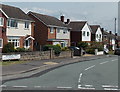
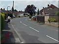
Frosty morning on Greenfields Road, Bridgnorth
1970s housing on the northern side of Bridgnorth.
Image: © Richard Law
Taken: 14 Jan 2022
0.03 miles
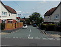
2
Greenfields Road, Bridgnorth
Viewed across Innage Lane.
Image: © Jaggery
Taken: 2 Jul 2014
0.04 miles
3
Innage Crescent, Bridgnorth
Viewed across Innage Lane. The part of Innage Crescent in view is an uncrescentlike straight line...
Image: © Jaggery
Taken: 2 Jul 2014
0.05 miles
4
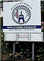
AFC Bridgnorth name sign
At the Innage Lane entrance to the clubhouse. http://www.geograph.org.uk/photo/4054355
Image: © Jaggery
Taken: 2 Jul 2014
0.07 miles
5
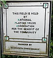
NPFA sign in Bridgnorth
Located near this http://www.geograph.org.uk/photo/4054368 children's play area.
NPFA is National Playing Fields Association.
Image: © Jaggery
Taken: 2 Jul 2014
0.08 miles
6
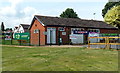
AFC Bridgnorth clubhouse, Bridgnorth
On the Innage Lane side of the football club's ground at Crown Meadow.
Image: © Jaggery
Taken: 2 Jul 2014
0.09 miles
7
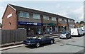
Andy Gas in Bridgnorth
Domestic service and installation engineers' premises at 1 Queensway Drive.
Image: © Jaggery
Taken: 2 Jul 2014
0.09 miles
8
Orchard Drive, Bridgnorth
From the corner of Innage Lane.
Image: © Jaggery
Taken: 2 Jul 2014
0.10 miles
9
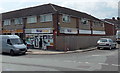
Queensway Drive Nisa Local store in Bridgnorth
Convenience store on the corner of Queensway Drive and Duchess Drive.
Sid's Plaice fish & chips shop is on the left.
Image: © Jaggery
Taken: 2 Jul 2014
0.10 miles
10
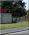
Innage Lane electricity substation, Bridgnorth
At the edge of Bridgnorth Youth Centre. http://www.geograph.org.uk/photo/4054301
The identifier on the Central Networks substation is INNAGE LANE S/STN No 9022.
Image: © Jaggery
Taken: 2 Jul 2014
0.10 miles