IMAGES TAKEN NEAR TO
Richmond Gardens, BRIDGNORTH, WV16 4HP
Introduction
This page details the photographs taken nearby to Richmond Gardens, WV16 4HP by members of the Geograph project.
The Geograph project started in 2005 with the aim of publishing, organising and preserving representative images for every square kilometre of Great Britain, Ireland and the Isle of Man.

There are currently over 7.5m images from over14,400 individuals and you can help contribute to the project by visiting https://www.geograph.org.uk
Image Map
Images are licensed for reuse under creativecommons.org/licenses/by-sa/2.0
Notes
- Clicking on the map will re-center to the selected point.
- The higher the marker number, the further away the image location is from the centre of the postcode.
Image Listing (71 Images Found)
Images are licensed for reuse under creativecommons.org/licenses/by-sa/2.0
Image
Details
Distance
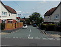
1
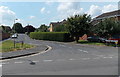
Richmond Gardens, Bridgnorth
Residential cul-de-sac viewed across Innage Lane.
Image: © Jaggery
Taken: 2 Jul 2014
0.03 miles
2
Youth Centre, Bridgnorth
Viewed across Innage Lane.
Image: © Jaggery
Taken: 2 Jul 2014
0.04 miles
3
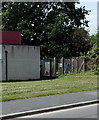
Innage Lane electricity substation, Bridgnorth
At the edge of Bridgnorth Youth Centre. http://www.geograph.org.uk/photo/4054301
The identifier on the Central Networks substation is INNAGE LANE S/STN No 9022.
Image: © Jaggery
Taken: 2 Jul 2014
0.05 miles
4
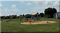
Children's play area on an NPFA field in Bridgnorth
On the south side of Innage Lane, near AFC Bridgnorth's Crown Meadow ground.
NPFA is National Playing Fields Association. http://www.geograph.org.uk/photo/4054371
Image: © Jaggery
Taken: 2 Jul 2014
0.05 miles
5
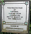
NPFA sign in Bridgnorth
Located near this http://www.geograph.org.uk/photo/4054368 children's play area.
NPFA is National Playing Fields Association.
Image: © Jaggery
Taken: 2 Jul 2014
0.08 miles
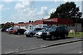
6
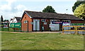
AFC Bridgnorth clubhouse, Bridgnorth
On the Innage Lane side of the football club's ground at Crown Meadow.
Image: © Jaggery
Taken: 2 Jul 2014
0.08 miles
7
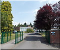
School entrance from Innage Lane, Bridgnorth
The school is St Leonard's CE Primary School. A notice on the wall shows
No Dog Walking. No Unauthorized use or Trespass. Nuisance on School Premises is an Offence.
Image: © Jaggery
Taken: 2 Jul 2014
0.09 miles
8
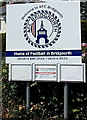
AFC Bridgnorth name sign
At the Innage Lane entrance to the clubhouse. http://www.geograph.org.uk/photo/4054355
Image: © Jaggery
Taken: 2 Jul 2014
0.09 miles
9
Innage Crescent, Bridgnorth
Viewed across Innage Lane. The part of Innage Crescent in view is an uncrescentlike straight line...
Image: © Jaggery
Taken: 2 Jul 2014
0.10 miles
10
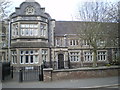
The former Bridgnorth Workhouse
Built in 1848 at the behest of the Bridgnorth Poor Law Union, which had been formed a decade or so earlier, this large workhouse replaced earlier (and presumably outgrown) premises elsewhere in the town. By the 1881 census, it had 4 staff (plus the master & matron's daughter) and 134 inmates, ranging in age from 3 months right up to 90 years. Most were relatively local, hailing from places such as Bridgnorth, Alveley, Eardington and Claverley, whilst there were also some poor souls from Middlesex, Essex, Kent, Somerset and Ireland. As in other rural workhouses, a depressingly high proportion of these residents are listed as Agricultural Labourers, which rather reflects on the way the economy was heading at that time. The buildings were falling out of use as a workhouse by the turn of the 20th century, after which they became a Public Assistance Institute for a while (similar to a workhouse but without so much of the stigma) then they became a residential home for the elderly around 1930, and have now been converted to residential use.
Image: © Richard Law
Taken: 31 Mar 2019
0.11 miles