IMAGES TAKEN NEAR TO
Innage Lane, BRIDGNORTH, WV16 4HJ
Introduction
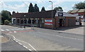
This page details the photographs taken nearby to Innage Lane, WV16 4HJ by members of the Geograph project.
The Geograph project started in 2005 with the aim of publishing, organising and preserving representative images for every square kilometre of Great Britain, Ireland and the Isle of Man.

There are currently over 7.5m images from over14,400 individuals and you can help contribute to the project by visiting https://www.geograph.org.uk
Image Map
Images are licensed for reuse under creativecommons.org/licenses/by-sa/2.0
Notes
- Clicking on the map will re-center to the selected point.
- The higher the marker number, the further away the image location is from the centre of the postcode.
Image Listing (338 Images Found)
Images are licensed for reuse under creativecommons.org/licenses/by-sa/2.0
Image
Details
Distance
1
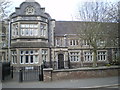
The former Bridgnorth Workhouse
Built in 1848 at the behest of the Bridgnorth Poor Law Union, which had been formed a decade or so earlier, this large workhouse replaced earlier (and presumably outgrown) premises elsewhere in the town. By the 1881 census, it had 4 staff (plus the master & matron's daughter) and 134 inmates, ranging in age from 3 months right up to 90 years. Most were relatively local, hailing from places such as Bridgnorth, Alveley, Eardington and Claverley, whilst there were also some poor souls from Middlesex, Essex, Kent, Somerset and Ireland. As in other rural workhouses, a depressingly high proportion of these residents are listed as Agricultural Labourers, which rather reflects on the way the economy was heading at that time. The buildings were falling out of use as a workhouse by the turn of the 20th century, after which they became a Public Assistance Institute for a while (similar to a workhouse but without so much of the stigma) then they became a residential home for the elderly around 1930, and have now been converted to residential use.
Image: © Richard Law
Taken: 31 Mar 2019
0.02 miles
2

OS benchmark - Bridgnorth, Innage lane
OS benchmark at the corner of a building (possibly now sheltered housing or flats) on Innage Lane; originally levelled at 68.586m above Ordnance Datum Newlyn.
Image: © Richard Law
Taken: 7 Dec 2013
0.02 miles
3
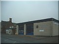
Bridgnorth Fire Station
The title just about sums it up...
Image: © Steve McShane
Taken: 29 Dec 2005
0.03 miles
4
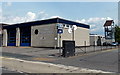
Bridgnorth Fire Station
Part of Shropshire Fire and Rescue Service, viewed across Innage Lane.
Image: © Jaggery
Taken: 2 Jul 2014
0.03 miles

6
Yard, William Williams, Bridgnorth
The yard is on the west side of the main building. http://www.geograph.org.uk/photo/4054083
Image: © Jaggery
Taken: 2 Jul 2014
0.04 miles
7
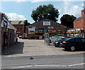
William Williams in Bridgnorth
Innage Lane premises of William Williams (Bridgnorth) Ltd, builders
and plumbers merchants (Trade and DiY (=Do it Yourself ie the general public)).
Image: © Jaggery
Taken: 2 Jul 2014
0.06 miles
8
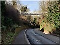
Footbridge across the B4373
The footbridge provides access to the Bridgnorth Endowed School.
Image: © Mat Fascione
Taken: 19 Feb 2023
0.08 miles
9
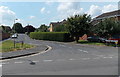
Richmond Gardens, Bridgnorth
Residential cul-de-sac viewed across Innage Lane.
Image: © Jaggery
Taken: 2 Jul 2014
0.08 miles
10
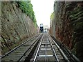
Cliff Railway from Low Town to High Town, Bridgnorth, Shropshire
Image: © Paul Russon
Taken: Unknown
0.09 miles