IMAGES TAKEN NEAR TO
Ebenezer Steps, BRIDGNORTH, WV16 4FD
Introduction
This page details the photographs taken nearby to Ebenezer Steps, WV16 4FD by members of the Geograph project.
The Geograph project started in 2005 with the aim of publishing, organising and preserving representative images for every square kilometre of Great Britain, Ireland and the Isle of Man.

There are currently over 7.5m images from over14,400 individuals and you can help contribute to the project by visiting https://www.geograph.org.uk
Image Map
Images are licensed for reuse under creativecommons.org/licenses/by-sa/2.0
Notes
- Clicking on the map will re-center to the selected point.
- The higher the marker number, the further away the image location is from the centre of the postcode.
Image Listing (1297 Images Found)
Images are licensed for reuse under creativecommons.org/licenses/by-sa/2.0
Image
Details
Distance
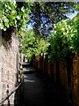
1
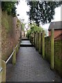
Ascending the Ebenezer Steps in Bridgnorth
The steps lead up from Ebenezer Row on Hollybush Road to New Road on Castle Hill.
Image: © Mat Fascione
Taken: 12 Mar 2023
0.01 miles
2
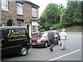
Pedestrians passing Ebenezers in Bridgnorth
Taken at the junction of Station Street with the B4373
Image: © Basher Eyre
Taken: 11 Aug 2009
0.01 miles
4
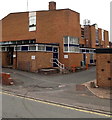
BT telephone exchange, New Road, Bridgnorth
Near the West Castle Street junction.
Image: © Jaggery
Taken: 2 Jul 2014
0.02 miles
5
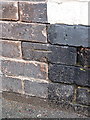
OS benchmark - Bridgnorth, The George hotel
An OS cutmark on a wall just outside the George Hotel (formerly the Hollybush Inn); originally levelled at 42.739m above Ordnance Datum Newlyn.
Image: © Richard Law
Taken: 25 Jan 2014
0.02 miles
6
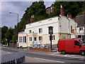
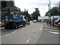
Hollyhead Makeover
The Inn on the Hollybush Road at Bridgnorth.
Image: © Gordon Griffiths
Taken: 25 Jun 2009
0.02 miles
7
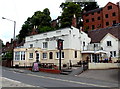
The George, Bridgnorth
The family-owned inn (B&B accommodation, bar and restaurant) in Hollybush Road
is opposite Bridgnorth railway station, the northern terminus of the Severn Valley Railway.
Image: © Jaggery
Taken: 2 Jul 2014
0.02 miles
8
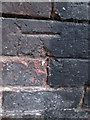
Ordnance Survey Cut Mark
This OS cut mark can be found on The George, No11 Hollybush Road. It marks a point 42.739m above mean sea level.
Image: © Adrian Dust
Taken: 25 Nov 2015
0.02 miles
9
Ebenezer Steps in Bridgnorth, Shropshire
This pathway links Hollybush Road with New Road.
Image: © Roger D Kidd
Taken: 31 May 2015
0.02 miles
10
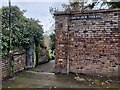
The top of the Ebenezer Steps in Bridgnorth
The steps lead down from New Road on Castle Hill to Ebenezer Row on Hollybush Road.
Image: © Mat Fascione
Taken: 12 Mar 2023
0.02 miles