IMAGES TAKEN NEAR TO
High Street, BRIDGNORTH, WV16 4DD
Introduction
This page details the photographs taken nearby to High Street, WV16 4DD by members of the Geograph project.
The Geograph project started in 2005 with the aim of publishing, organising and preserving representative images for every square kilometre of Great Britain, Ireland and the Isle of Man.

There are currently over 7.5m images from over14,400 individuals and you can help contribute to the project by visiting https://www.geograph.org.uk
Image Map
Images are licensed for reuse under creativecommons.org/licenses/by-sa/2.0
Notes
- Clicking on the map will re-center to the selected point.
- The higher the marker number, the further away the image location is from the centre of the postcode.
Image Listing (1445 Images Found)
Images are licensed for reuse under creativecommons.org/licenses/by-sa/2.0
Image
Details
Distance
2
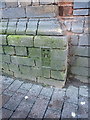
OS Flush Bracket S6051 - Bridgnorth High Town
Flush Bracket S6051 on the wall of a building at the corner of Listley St and High St; originally levelled at 66.444m above Ordnance Datum Newlyn, and used during the 3rd geodetic levelling of England and Wales between 1950 & 1968.
Image: © Richard Law
Taken: 30 Dec 2013
0.00 miles
3
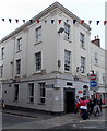
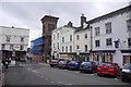
HSBC in Bridgnorth
Bank branch at 43a High Street, on the corner of Listley Street.
Image: © Jaggery
Taken: 2 Jul 2014
0.00 miles
4
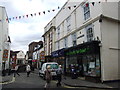
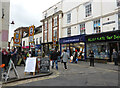
High Street Market
The view down the Shropshire town street on a Saturday in Bridgnorth.
Image: © Gordon Griffiths
Taken: 30 Jan 2016
0.01 miles
5
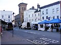
High Street, Bridgnorth
Taken on a Claret replenishing run to Tanners. Some Edinburgh traditions are sacred.
Even if you are not buying wine, Bridgnorth is always worth a visit.
Image: © Richard Webb
Taken: 16 Oct 2018
0.01 miles
6
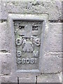
Ordnance Survey Flush Bracket (S6051)
This OS Flush Bracket can be found on the building at the junction of Listley Street. It marks a point 66.444m above mean sea level.
Image: © Adrian Dust
Taken: 24 Nov 2015
0.01 miles
7
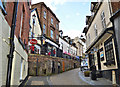
The Cartway, Bridgnorth
The steep climb is almost over as the Cartway nears the junction with High Street.
Image: © Philip Pankhurst
Taken: 5 Apr 2016
0.01 miles
8
Waterloo Terrace, Bridgnorth
At the top of The Cartway.
Image: © Chris Allen
Taken: 17 Oct 2015
0.01 miles
9
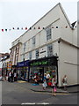
Alley Katz Toy Shop in Bridgnorth
Viewed from High Street. The street name sign on the wall shows Waterloo Terrace.
A Cancer Research UK shop is next door.
Image: © Jaggery
Taken: 2 Jul 2014
0.01 miles
10
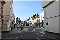
High Street from Postern Gate, Bridgnorth
Image: © David Howard
Taken: 30 May 2020
0.01 miles