IMAGES TAKEN NEAR TO
Pound Street, BRIDGNORTH, WV16 4BS
Introduction
This page details the photographs taken nearby to Pound Street, WV16 4BS by members of the Geograph project.
The Geograph project started in 2005 with the aim of publishing, organising and preserving representative images for every square kilometre of Great Britain, Ireland and the Isle of Man.

There are currently over 7.5m images from over14,400 individuals and you can help contribute to the project by visiting https://www.geograph.org.uk
Image Map
Images are licensed for reuse under creativecommons.org/licenses/by-sa/2.0
Notes
- Clicking on the map will re-center to the selected point.
- The higher the marker number, the further away the image location is from the centre of the postcode.
Image Listing (720 Images Found)
Images are licensed for reuse under creativecommons.org/licenses/by-sa/2.0
Image
Details
Distance
1
Squirrel Court, Bridgnorth
Flats in Pound Street.
Image: © Jaggery
Taken: 2 Jul 2014
0.02 miles
2
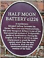
Section of the old Town Walls
Probably dating from the 13th century, and now built into the retaining wall on the east side of Squirrel Bank at the top of Hollybush Road, this was granted Grade II listed status in 1974 https://www.britishlistedbuildings.co.uk/101367492-fragment-of-town-walls-to-south-of-remains-of-half-moon-battery-bridgnorth#.WQJYktQrLGg
Image: © Richard Law
Taken: 5 Apr 2017
0.02 miles
3
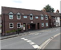
Frank Childs & Son Ltd in Bridgnorth town centre
Image: © Basher Eyre
Taken: 11 Aug 2009
0.02 miles
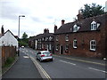
4
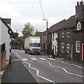
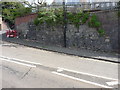
Pound Street, Bridgnorth
Once the main A458 before the bypass was built.
Image: © Richard Webb
Taken: 15 Oct 2019
0.02 miles
5
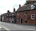
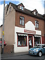
West side of Pound Street, Bridgnorth
Viewed from the corner of Whitburn Street.
Image: © Jaggery
Taken: 2 Jul 2014
0.02 miles
6
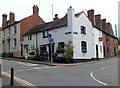
Corner of St Mary's Street and Listley Street, Bridgnorth
Listley Street is on the right.
Image: © Jaggery
Taken: 2 Jul 2014
0.03 miles
7
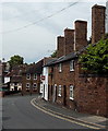
Prominent chimneys in Listley Street, Bridgnorth
At the NW end of Listley Street, near the corner of St Mary's Street.
Image: © Jaggery
Taken: 2 Jul 2014
0.03 miles
9
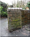
OS benchmark - Bridgnorth, junction of Rose Lane & The Yards
An OS cutmark in a brick pillar bounding the south side of the narrow path known as Rose Lane, which connects Hollybush Lane to Oldbury Wells. The mark was originally levelled at 56.056m above Ordnance Datum Newlyn.
Image: © Richard Law
Taken: 25 Jan 2014
0.03 miles