IMAGES TAKEN NEAR TO
Bank Steps, BRIDGNORTH, WV16 4BQ
Introduction
This page details the photographs taken nearby to Bank Steps, WV16 4BQ by members of the Geograph project.
The Geograph project started in 2005 with the aim of publishing, organising and preserving representative images for every square kilometre of Great Britain, Ireland and the Isle of Man.

There are currently over 7.5m images from over14,400 individuals and you can help contribute to the project by visiting https://www.geograph.org.uk
Image Map
Images are licensed for reuse under creativecommons.org/licenses/by-sa/2.0
Notes
- Clicking on the map will re-center to the selected point.
- The higher the marker number, the further away the image location is from the centre of the postcode.
Image Listing (1312 Images Found)
Images are licensed for reuse under creativecommons.org/licenses/by-sa/2.0
Image
Details
Distance
1
Severn Steps in Bridgnorth, Shropshire
The steps lead down to River Side from Cartway.
Image: © Roger Kidd
Taken: 23 Nov 2018
0.01 miles
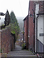
2
Bank Steps in Bridgnorth
These steps lead up from Riverside to the Cartway.
Image: © Mat Fascione
Taken: 29 Jan 2023
0.01 miles
4
Riverside
Beside the Severn, Bridgnorth.
Image: © Richard Webb
Taken: 7 Aug 2017
0.01 miles
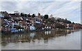
5
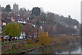
Bridgnorth by the River Severn in Shropshire
This telephoto assisted image shows Bridgnorth on the western side of the River Severn, seen from the bridge. St Leonard's Church can be seen on the skyline.
Image: © Roger Kidd
Taken: 23 Nov 2018
0.01 miles
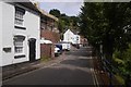
6
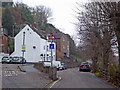
River Side in Bridgnorth, Shropshire
On a gloomy autumn morning, this is looking north along River Side, a lane by the River Severn on its west bank and north of the bridge.
Image: © Roger Kidd
Taken: 23 Nov 2018
0.02 miles
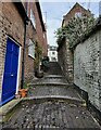
8
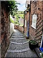
Descending Bank Steps in Bridgnorth
These steps lead up from Riverside to the Cartway.
Image: © Mat Fascione
Taken: 7 May 2023
0.02 miles
9
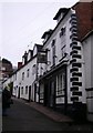
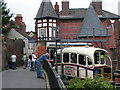
The Black Boy Inn, Bridgnorth
Apparently named after Charles II and his apparently dusky complexion.
Image: © Chris Whippet
Taken: 29 Nov 2009
0.02 miles
10
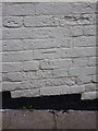
OS benchmark - Bridgnorth, no 66 Cartway
OS cutmark in the bricks of no 66 Cartway; originally levelled at 46.122m above Ordnance Datum Newlyn.
Image: © Richard Law
Taken: 30 Dec 2013
0.02 miles