IMAGES TAKEN NEAR TO
Friars Street, BRIDGNORTH, WV16 4BJ
Introduction
This page details the photographs taken nearby to Friars Street, WV16 4BJ by members of the Geograph project.
The Geograph project started in 2005 with the aim of publishing, organising and preserving representative images for every square kilometre of Great Britain, Ireland and the Isle of Man.

There are currently over 7.5m images from over14,400 individuals and you can help contribute to the project by visiting https://www.geograph.org.uk
Image Map
Images are licensed for reuse under creativecommons.org/licenses/by-sa/2.0
Notes
- Clicking on the map will re-center to the selected point.
- The higher the marker number, the further away the image location is from the centre of the postcode.
Image Listing (1091 Images Found)
Images are licensed for reuse under creativecommons.org/licenses/by-sa/2.0
Image
Details
Distance
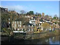
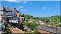
3
Old houses in Friars Street
A group of old houses fronting onto Friars Street. This is a long narrow lane, which is one of the town's many quiet back streets. Named after the Franciscan Friary, which used to be near the junction of Friars Street with Cartway. There are no remains, just a grassed area. Image
Image: © P L Chadwick
Taken: 10 Jul 2010
0.02 miles
4
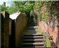
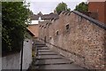
Ascending Granary Steps
The steps lead down from St Leonard's Church towards the River Severn.
Image: © Mat Fascione
Taken: 21 Apr 2011
0.02 miles
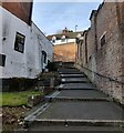
5
Steps, Bridgnorth
Steps between River Side and Friar's Street.
Image: © Richard Webb
Taken: 7 Aug 2017
0.02 miles
6
Friars Loade Steps at Bridgnorth
These steps connect Southwell Riverside with Friar's Street.
Image: © Mat Fascione
Taken: 29 Jan 2023
0.02 miles
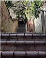
7
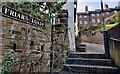
The top of the Friars Loade Steps at Bridgnorth
These steps connect Southwell Riverside with Friar's Street.
Image: © Mat Fascione
Taken: 29 Jan 2023
0.02 miles
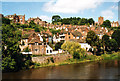
9

The ruins of a medieval Franciscan Friary
This is the site of a medieval Friary established by the Franciscan Order between 1224 and 1244. The Friary was closed down at the time of the Dissolution of the Monasteries in 1538, the buildings then changed hands frequently. In 1826 demolition of the upper part of the Friary took place for the construction of the Southwells Carpet Works. After the factory was demolished in 1989 the remains of the Friary were uncovered, these foundations are still visible today, located along Southwell Riverside in Bridgnorth.
Image: © Mat Fascione
Taken: 29 Jan 2023
0.03 miles
10
The Granary Steps in Bridgnorth
These steps run between Friar's Street and St Leonard's Close opposite the church.
Image: © Mat Fascione
Taken: 29 Jan 2023
0.03 miles