
IMAGES TAKEN NEAR TO
Stoneway Steps, BRIDGNORTH, WV16 4BD
Introduction
This page details the photographs taken nearby to Stoneway Steps, WV16 4BD by members of the Geograph project.
The Geograph project started in 2005 with the aim of publishing, organising and preserving representative images for every square kilometre of Great Britain, Ireland and the Isle of Man.

There are currently over 7.5m images from over14,400 individuals and you can help contribute to the project by visiting https://www.geograph.org.uk
Image Map
Images are licensed for reuse under creativecommons.org/licenses/by-sa/2.0
Notes
- Clicking on the map will re-center to the selected point.
- The higher the marker number, the further away the image location is from the centre of the postcode.
Image Listing (1475 Images Found)
Images are licensed for reuse under creativecommons.org/licenses/by-sa/2.0
Image
Details
Distance
1

Bridgnorth Cliff Railway - lower station
The railway was built in 1892, is 201 feet long and a has a rise of 111 feet on a gradient of 1 in 1.8. The gauge is 3' 8.5". It was originally a water balance system but converted to electrical operation in 1934. The current cars were installed in 1955 and resembled contemporary motor coaches.
Image: © Chris Allen
Taken: 1 Apr 2026
0.00 miles
2

Bridgnorth Cliff Railway - lower station
The railway was built in 1892, is 201 feet long and a has a rise of 111 feet on a gradient of 1 in 1.8. The gauge is 3' 8.5". It was originally a water balance system but converted to electrical operation in 1934. The current cars were installed in 1955 and resembled contemporary motor coaches.
Image: © Chris Allen
Taken: 1 Apr 2026
0.00 miles
3
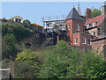
High Town Station
The upper station of a funicular railway that links the High and Low towns of Bridgnorth. The Castle Hill Railway is the steepest and only inland funicular railway in the country.
Image: © Mat Fascione
Taken: 21 Apr 2011
0.01 miles
4
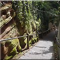
Stoneway Steps
One of the steep ways down from High Town.
Image: © Richard Webb
Taken: 7 Aug 2017
0.01 miles
5
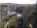
Funicular railway
The railway opened on 7th July 1892
Image: © Tim Glover
Taken: 19 Feb 2012
0.01 miles
6
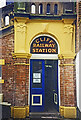
Cliff Railway Station
The entrance to the cable railway between High and Low Town.
Image: © Des Blenkinsopp
Taken: Unknown
0.01 miles
7
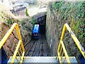
Bridgnorth - Cliff Railway - Funicular carriages
This photo was taken from the rear of the ascending funicular carriage looking down the steep railway slope at its counterbalanced twin which is approaching the lower station. The railway links Castle Walk, High Town with Riverside, Low Town, 111' (34m) down the cliff.
See also Image] which has more information.
Image: © Rob Farrow
Taken: 30 Jan 2022
0.01 miles
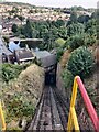
9
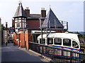
Bridgnorth Cliff Railway
The Cliff railway opened in 1892, between High and Low town.
Image: © Gordon Griffiths
Taken: 25 Jun 2009
0.01 miles
10
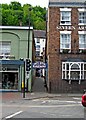
Entrance to the Low Town station of the Bridgnorth Cliff Railway, Underhill Street
This narrow passage leads to the Low Town station of the famous Bridgnorth Cliff Railway, which is apparently the UK's only working inland cliff railway. It opened in 1892 and is probably the easiest way of getting to High Town. It is run by the Bridgnorth Castle Hill Railway Company Limited.
Image
Image: © P L Chadwick
Taken: 6 Jul 2010
0.01 miles