IMAGES TAKEN NEAR TO
Bank Street, BRIDGNORTH, WV16 4AJ
Introduction
This page details the photographs taken nearby to Bank Street, WV16 4AJ by members of the Geograph project.
The Geograph project started in 2005 with the aim of publishing, organising and preserving representative images for every square kilometre of Great Britain, Ireland and the Isle of Man.

There are currently over 7.5m images from over14,400 individuals and you can help contribute to the project by visiting https://www.geograph.org.uk
Image Map
Images are licensed for reuse under creativecommons.org/licenses/by-sa/2.0
Notes
- Clicking on the map will re-center to the selected point.
- The higher the marker number, the further away the image location is from the centre of the postcode.
Image Listing (1456 Images Found)
Images are licensed for reuse under creativecommons.org/licenses/by-sa/2.0
Image
Details
Distance
1
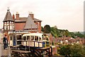
Bridgnorth - Castle Hill Railway Co. Ltd
The funicular railway that connects High Town with Low Town, in Bridgnorth, Shropshire.
Image: © Ian Slater
Taken: 25 May 2009
0.01 miles
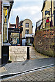
3
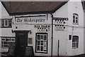
Old road signs, Bridgnorth
On the Shakespeare pub, relics of a time when through traffic traversed High Town.
Image: © Richard Webb
Taken: 7 Aug 2017
0.01 miles
5
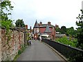
Castle Terrace looking to the High Town Station of the Bridgnorth Cliff Railway
Walking in this direction soon leads into the town centre.
Image: © P L Chadwick
Taken: 6 Jul 2010
0.01 miles
6

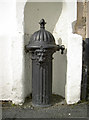
Water conduit head outside the former Trustee Savings Bank
This Grade II listed http://www.britishlistedbuildings.co.uk/101392278-conduit-head-adjacent-to-the-former-trustee-savings-bank-bridgnorth black pipehead represents a visible portion of the mid-19th century public water supply system installed throughout Bridgnorth from the 1850s onwards. The basis of the system was a pumped arrangement to bring water from the Severn to a filtration works above the town. This was connected to a network of pipes extending through the town, and dispensed through conduit heads such as this in a variety of strategic locations. A handful survive - this one, plus another at the corner of Westgate and Ludlow Road (just offhsot to the left in Image, and seen close-up in Image) There is a similar (pump-handled) head to the north of Low Town, now demoted to a decorative feature in a flowerbed near the junction of Stanley Lane and Bramble Ridge.
Image: © Richard Law
Taken: 5 Apr 2017
0.01 miles
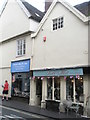
7
My Little Wedding Shop, Bridgnorth
With a cute Dutch gable, just off the Cartway.
Image: © Philip Pankhurst
Taken: 5 Apr 2016
0.01 miles
8
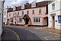
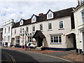
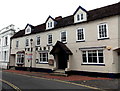
The Habit, 30-32 East Castle Street
The Habit is a restaurant and bar, and judging by its appearance including the coach arch on the right, was almost certainly at one time a coaching inn. It was known until fairly recently as The Ball Hotel, and in the 1881 Census appears as The Ball Inn.
East Castle Street was built in the early 18th century.
Image: © P L Chadwick
Taken: 10 Jul 2010
0.02 miles
9
A lion in East Castle Street
Some fancy ironwork, including its own niche, in the restaurant buildings.
Image: © Neil Owen
Taken: 21 Jul 2010
0.02 miles
10
The Habit, Bridgnorth
Restaurant and bar at the northern end of East Castle Street.
In early July 2014, there is a FOR SALE/TO LET board on the wall.
The board states that the premises are complete with furniture and equipment, and ready to open.
Image: © Jaggery
Taken: 2 Jul 2014
0.02 miles