IMAGES TAKEN NEAR TO
Danery Meadow Park, BRIDGNORTH, WV15 6QF
Introduction
This page details the photographs taken nearby to Danery Meadow Park, WV15 6QF by members of the Geograph project.
The Geograph project started in 2005 with the aim of publishing, organising and preserving representative images for every square kilometre of Great Britain, Ireland and the Isle of Man.

There are currently over 7.5m images from over14,400 individuals and you can help contribute to the project by visiting https://www.geograph.org.uk
Image Map
Images are licensed for reuse under creativecommons.org/licenses/by-sa/2.0
Notes
- Clicking on the map will re-center to the selected point.
- The higher the marker number, the further away the image location is from the centre of the postcode.
Image Listing (67 Images Found)
Images are licensed for reuse under creativecommons.org/licenses/by-sa/2.0
Image
Details
Distance
1
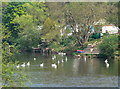
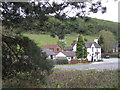
Swans at Quatford
Along the River Severn in Shropshire.
Image: © Mat Fascione
Taken: 21 Apr 2011
0.02 miles
2
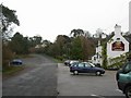
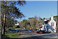
Quatford
The Danery pub. At the end of the road the church is tucked behind the trees. This section of road appears to be the original course of the main road. The A442 is just to the left.
Image: © Jennifer Luther Thomas
Taken: 1 Dec 2006
0.06 miles
3
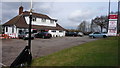
Formerly a "Little Chef" now Tony's.
The Little Chef chain of roadside restaurants was, and still is, an iconic feature of our road netweork, but not all have survived. This one lay empty for many years but has re-emerged under new ownership.
Image: © Mike Dodman
Taken: 10 Apr 2009
0.06 miles
4
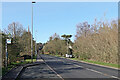
A442 approaching Quatford in Shropshire
Looking north towards Bridgnorth.
Image: © Roger Kidd
Taken: 19 Mar 2022
0.07 miles
7
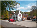
The Danery, Quatford
We had lunch here. It's a nice pub. http://www.thedanerybridgnorth.co.uk/
The name is apparently unique but of uncertain origin.
Quatford too is an unusual name but unchanged for centuries, recorded as Quattford in 1030, and meaning Cwatt's Ford, whoever he was.
Image: © Des Blenkinsopp
Taken: 23 Apr 2012
0.09 miles
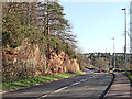
8
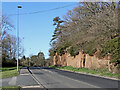
A442 approaching Quatford in Shropshire
Looking north towards Bridgnorth.
The rock exposure is of Permian Bridgnorth Sandstone. These rocks represent fossilised sand dunes and were part of a very large desert that existed around 300 million years ago when this land was a sub-tropical part of the single continent known as Pangea.
Image: © Roger Kidd
Taken: 19 Mar 2022
0.09 miles
9
Sandstone by the A442 south of Quatford in Shropshire
Looking south towards Kidderminster.
The exposure is of Permian Bridgnorth Sandstone. These rocks consist of fossilised sand dunes which were part of a very large desert that existed around 300 million years ago when this land was a sub-tropical part of the single continent known as Pangea.
Image: © Roger Kidd
Taken: 19 Mar 2022
0.09 miles
10
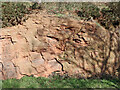
Permian Bridgnorth Sandstone at Quatford in Shropshire
By the A442 road about 160 metres south of the Danery public house at Quatford.
The exposure is of Permian Bridgnorth Sandstone. These rocks consist of fossilised sand dunes which were part of a very large desert that existed around 300 million years ago when this land was a sub-tropical part of the single continent known as Pangea.
Image: © Roger Kidd
Taken: 19 Mar 2022
0.10 miles