IMAGES TAKEN NEAR TO
Romsley, BRIDGNORTH, WV15 6HS
Introduction
This page details the photographs taken nearby to WV15 6HS by members of the Geograph project.
The Geograph project started in 2005 with the aim of publishing, organising and preserving representative images for every square kilometre of Great Britain, Ireland and the Isle of Man.

There are currently over 7.5m images from over14,400 individuals and you can help contribute to the project by visiting https://www.geograph.org.uk
Image Map
Images are licensed for reuse under creativecommons.org/licenses/by-sa/2.0
Notes
- Clicking on the map will re-center to the selected point.
- The higher the marker number, the further away the image location is from the centre of the postcode.
Image Listing (5 Images Found)
Images are licensed for reuse under creativecommons.org/licenses/by-sa/2.0
Image
Details
Distance
1
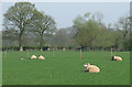
Sheep Grazing, New Barns Farm, Hartsgreen, Shropshire
Land in the vicinity is shared between grazing and the growing of cereal crops.
Image: © Roger Kidd
Taken: 13 Apr 2007
0.18 miles
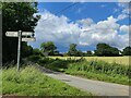
3
Beacon Lane at Hartsgreen
At the junction with Herons Gate Road.
Image: © Mat Fascione
Taken: 10 Feb 2021
0.20 miles
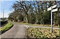
4
It's easy to get lost down these lanes - especially when some bright spark turns a sign around!
Image: © Row17
Taken: 4 Dec 2008
0.20 miles
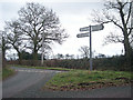
5
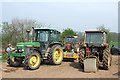
Tractors, New Barns Farm, Hartsgreen, Shropshire
Image: © Roger Kidd
Taken: 13 Apr 2007
0.23 miles