IMAGES TAKEN NEAR TO
Quatt, BRIDGNORTH, WV15 6HB
Introduction
This page details the photographs taken nearby to WV15 6HB by members of the Geograph project.
The Geograph project started in 2005 with the aim of publishing, organising and preserving representative images for every square kilometre of Great Britain, Ireland and the Isle of Man.

There are currently over 7.5m images from over14,400 individuals and you can help contribute to the project by visiting https://www.geograph.org.uk
Image Map
Images are licensed for reuse under creativecommons.org/licenses/by-sa/2.0
Notes
- Clicking on the map will re-center to the selected point.
- The higher the marker number, the further away the image location is from the centre of the postcode.
Image Listing (10 Images Found)
Images are licensed for reuse under creativecommons.org/licenses/by-sa/2.0
Image
Details
Distance
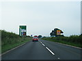
1
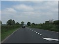
A442 north of the Hampton Loade junction
Image: © Peter Whatley
Taken: 8 Jun 2013
0.03 miles
3
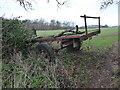
Old abandoned trailer at a gateway into a field
Allowing horses and riders to squeeze past.
Image: © Jeremy Bolwell
Taken: 7 Jan 2022
0.07 miles
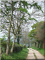
4
Bridleway near Quatt
Open to all traffic.
Nice.
Image: © Jeremy Bolwell
Taken: 7 Jan 2022
0.12 miles
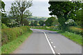
5
A442 southbound nears turn for Hampton Loade
Image: © Colin Pyle
Taken: 20 Jun 2013
0.17 miles
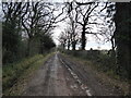
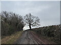
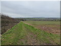
6
Byway near Quatt, Shropshire
This unsurfaced track is classified as a byway open to all traffic. It runs about two miles through the fields from Birdsgreen, almost into Quatt.
Image: © Roger Kidd
Taken: 17 Apr 2007
0.18 miles
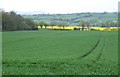
7
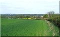
Crop Fields near Quatt, Shropshire
Cereals and rape dominate the fields round here, with some ground set aside for grazing. The A442 is on the right of the hedge.
Image: © Roger Kidd
Taken: 17 Apr 2007
0.21 miles
8
Crown of the byway
I am looking forward to the outlook from this potential viewpoint.
Image: © Jeremy Bolwell
Taken: 7 Jan 2022
0.21 miles
9
Crop Fields near Hampton Loade, Shropshire
Cereal crops and rape are dominant locally.Half a mile beyond the rape field is the River Severn, and on the skyline is Titterstone Clee. Burntcroft Coppice is on the left.
Image: © Roger Kidd
Taken: 17 Apr 2007
0.23 miles
10
Distant views towards the Clee Hills from above the Severn Valley above Hampton Loade
Nice! Snow and all.
Image: © Jeremy Bolwell
Taken: 7 Jan 2022
0.24 miles